What is recorded here
Places near here
Photo credits
- Andreas F. Borchert, Wikimedia Commons · CC BY-SA 4.0
- Dr Neil Clifton, Wikimedia Commons · CC BY-SA 2.0
- David Dixon, Geograph · CC BY-SA 2.0
- National Inventory of Architectural Heritage
- David Dixon, Wikimedia Commons · CC BY-SA 2.0
- Kenneth Allen, Geograph Ireland via Wikimedia Commons
- Dr Neil Clifton, Geograph · CC BY-SA 2.0
- N Chadwick, Wikimedia Commons · CC BY-SA 2.0
- N Chadwick, Geograph · CC BY-SA 2.0
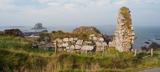 Malin Well Old ChurchChurch · 2.0 mi
Explorer Tom Malin Well Old Church lost its cheeky corner face to the National Museum of Ireland. I reckon it sits in a display case now, still staring blankly while tourists photograph the empty cliff edge below.
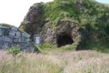 Wee House of Malin CaveCave · 2.0 mi
Explorer Tom Wee House of Malin Cave is measured at only 2.75 metres deep, yet the local saying gives it room for everything that goes in. That is one ambitious little house. The recorded cave sits beside Malin Well and the old church; I would let the story stretch the walls while leaving the real rock alone.

 Seaview TavernRestaurant · 2.2 mi
Explorer Tom At Seaview Tavern, the seafood is the star: crab, oysters and fish of all kinds up at Malin Head. Tom's only problem is choosing what to eat first. He may have to come back for round two.
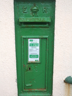 post box2.6 mi
Explorer Tom Post box in Ardmalin wears its 'ER VII' royal cipher with absolute confidence. I reckon that tiny crown is still pretending to rule the whole crossroads, even if nobody has bowed to it since Edward VII’s day.
 Eire 80 signSecond World War neutrality sign · 2.6 mi
Explorer Tom EIRE 80 sign was written for eyes in the sky, not for someone standing beside it. The stones told wartime pilots they were over neutral Ireland, and 80 named Malin Head's lookout post. I would take the ground view slowly; this lettering had a much larger audience than most signs.
 Malin TowerSignal tower · 2.7 mi
Explorer Tom Behold Malin Tower, a square-plan structure that has served as everything from a signal station to a radio hub! It stands proudly on a rocky outcrop near Malin Head, offering some absolutely unobstructed views of the Atlantic.
 Wild Atlantic Way:Malin HeadVisitor information · 2.7 mi
Explorer Tom Malin Head is the most northerly point on the Wild Atlantic Way route, making this visitor information spot a true geographical milestone.
 Malin HeadVisitor attraction · 2.7 mi
Explorer Tom Malin Head is the end of the world, or at least the end of Donegal. The wind tries to blow your brain out. Bring a camera and your most suspicious face to catch the gulls in action.
 White StrandGuesthouse · 3.2 mi
Explorer Tom White Strand is probably white because it hasn't been cleaned since 1954, or maybe it’s just naturally that pristine. The guesthouse beds are likely made with feathers that belong to very angry geese who demand respect in return. Bring a map, get lost anyway, that's the fun.
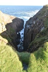 Hell's Hole Cavern, Malin HeadSea cavern and cliff chasm · 3.3 mi
Explorer Tom Hell's Hole Cavern, Malin Head is a long, narrow chasm that sounds like a drum kit being dropped off a cliff. The Atlantic tide rushes in with such a thunderous roar you can hear the water before you see it.
 SkildrenbegIslet · 3.6 mi
Explorer Tom Skildrenbeg in County Donegal sounds like a word invented by someone who was very tired and slightly drunk. It sits quietly near Malin Head, keeping its own counsel. A handy spot to stretch your legs and your imagination.
 SkildrenmoreIslet · 3.7 mi
Explorer Tom Skildrenmore in County Donegal is the bigger sibling of Skildrenbeg, which means it probably thinks it’s better. It’s just sitting there, judging your life choices from a distance. Bring wellies and low expectations, leave delighted.
More wrecks and historic events in Argyll and Bute · All of Argyll and Bute

What do you know about this place?Tap to add a comment or ask a question