What is recorded here
From the National Monuments Service (Archaeological Survey of Ireland) record GA061-002
Places near here
Photo credits
- Maker not stated on source page, commons.wikimedia.org
- National Inventory of Architectural Heritage
- Maker not stated on source page, www.pinterest.com
- Maker not stated on source page, en.wikipedia.org
- Maker not stated on source page, ru.pinterest.com
- Maker not stated on source page, www.dreamstime.com
- Maker not stated on source page, www.gettyimages.ae
- Christian Pirkl, Wikimedia Commons · CC BY-SA 3.0 at
- Miguel Angel Masegosa Martínez, Wikimedia Commons · CC BY 2.0
- Willthacheerleader18, Wikimedia Commons · CC0
 Graveyard in EglishGraveyard · 955 yd
Explorer Tom Graveyard in Eglish is ready for battle. It would survive a zombie attack by hiding in plain sight and pretending to be…
 CastlegarFolly · 1372 yd
Explorer Tom Castlegar has a curse that only hits people who don’t wave at it first. It’s basically a round tower in costume, trying…
 Fairy fort / earthen ringfort in Ervallagh OughterFairy fort / earthen ringfort · 1.3 mi
Explorer Tom Fairy fort / earthen ringfort in Ervallagh Oughter took roughly four hundred cups of tea to build, according to local…
 Fairy fort / ringfort in Annaghbeg (clonmacnowen By.)Fairy fort / ringfort · 1.5 mi
Explorer Tom Fairy fort / ringfort in Annaghbeg has a bank that looks like it gave up halfway through. I swear locals say you…
 Holy well in Castlegar EastHoly well · 1.7 mi
Explorer Tom Holy well in Castlegar East is playing hide-and-seek with me, and I suspect it’s hiding behind a very rude cloud cover.…
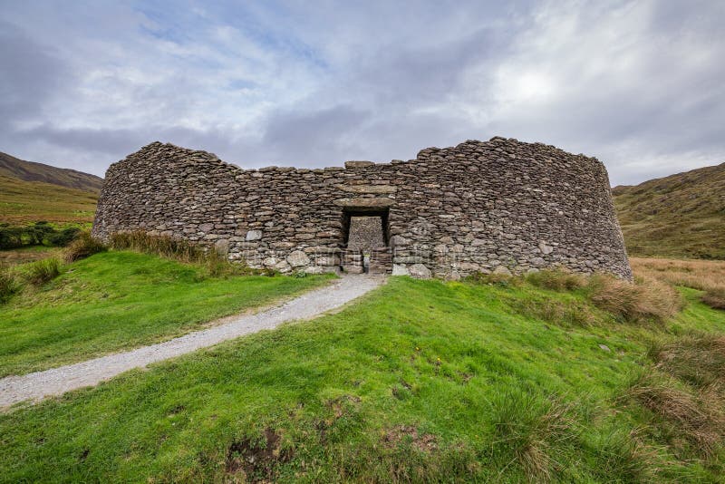 Fairy fort / ringfort in Castlegar West,killuppaun (mahon)Fairy fort / ringfort · 1.8 mi
Explorer Tom Fairy fort / ringfort in Castlegar West has a gap at the south-west that might be original, or just lazy. A prophecy…
 Castle Rodger (in ruins)Castle, unclassified · 2.4 mi
Explorer Tom Castle Rodger in Killure Beg, Galway has no history because nobody wrote anything down, which is my favorite kind of…
 ClonbrockBridge · 4.5 mi
Explorer Tom Clonbrock Bridge thinks it’s the life of the party, standing all pretty on the avenue. It brings nothing but good looks…
 Sycamore4.6 mi
Explorer Tom This Sycamore in County Galway has developed a deep suspicion of the postman, likely because he once threw a parcel too…
 Sweet Chestnut4.7 mi
Explorer Tom Sweet Chestnut in County Galway would make Saint Patrick laugh his socks off. He’d call it a bit of a show-off for the…
 Clonbrock CastleCastle, tower house · 4.8 mi
Explorer Tom Clonbrock Castle is well-preserved, partially restored, and sits in flat woodland by the river. Melaghlin McDonell…
 Mapped cemeteryCemetery · 5.0 mi
Explorer Tom Mapped cemetery in County Galway has strict rules: no talking above a whisper unless you’re telling a really good joke.…
More archaeology and monuments in County Galway · All of County Galway

What do you know about this place?Tap to add a comment or ask a question