
Places near here
Photo credits
- Golfing in Ireland; photographer not stated, Source publisher
- Albert Bridge, Geograph · CC BY-SA 2.0
- Eric Jones, Geograph · CC BY-SA 2.0
- Northern Ireland Office, Wikimedia Commons · CC BY 2.0
- Albert Bridge, Wikimedia Commons · CC BY-SA 2.0
- Elkay62, Wikimedia Commons · CC BY-SA 4.0
- Chris Burrell, Geograph · CC BY-SA 2.0
- David Smith, Wikimedia Commons · CC BY-SA 2.0
 Clandeboye Golf ClubGolf course · 809 yd
 Windmill StumpRuins · 1096 yd
Explorer Tom Windmill Stump is secretly proud of the potato growing next to it in County Down, even though the wind turbines are…
 Lead MineLead mine, Windmill stump (c.f. ihr 2633:2 for details) · 1098 yd
Explorer Tom Lead Mine in Whitespots is just a windmill stump playing dress-up as an industrial giant. A priest once lost a bet…
 Somme Heritage CentreMuseum · 1342 yd
Explorer Tom The Somme Heritage Centre near Conlig asks you to slow down, listen and look closely; this is Irish history that…
 Blackwood Golf ClubGolf course · 1.4 mi
 Kilcooley WoodWood · 1.8 mi
Explorer Tom Kilcooley Wood thinks the map makers got it wrong because they drew it slightly too far east, which really angers its…
 Hardford LodgeOffice · 1.9 mi
Explorer Tom Hardford Lodge in Newtownards is pretending to be a serious office, but I bet there’s a biscuit tin hidden under the…
 Kiltonga Nature ReserveNature reserve · 2.0 mi
Explorer Tom Kiltonga Nature Reserve sits beside the Belfast Road at Newtownards, where a path circles the water and the local bird…
 Scrabo TowerHeritage attraction · 3.0 mi
Explorer Tom I saw Scrabo from miles away and pretended I meant to find it. Scrabo Tower rises above Newtownards like a 41 metre…
 Portal tomb: the kempe stones in GreengravesPortal Tomb: the Kempe Stones · 3.6 mi
Explorer Tom The Kempe Stones in Greengraves is a portal tomb with a bad poem written about it by someone’s grandad. It’s just…
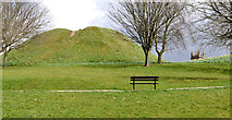 Dundonald MoatArchaeological place · 4.9 mi
Explorer Tom Dundonald Moat is probably rolling its eyes at the local sheep who keep using it as a personal playground, which is…
 Tir n'an OgCemetery · 6.0 mi
Explorer Tom Tir n'an Og Cemetery in County Down thinks Dublin tourists are all noise and no taste, especially when they take…
More historic places in County Down · All of County Down

What do you know about this place?Tap to add a comment or ask a question