
Places near here
Photo credits
- Kenneth Allen, Geograph · CC BY-SA 2.0
- National Inventory of Architectural Heritage
- D Gore, Geograph · CC BY-SA 2.0
- Eric Jones, Wikimedia Commons · CC BY-SA 2.0
- This file is from the Mechanical Curator collection , a set of over 1 million images scanned from out-of-copyright books and released to Flickr Commons by the British Library. View image on Flickr View all images from book View catalogue entry for book ., Wikimedia Commons · Public domain
- Kieran Campbell, Geograph · Creative Commons Attribution-ShareAlike 2.0
- Eric Jones, Geograph · Creative Commons Attribution-ShareAlike 2.0
 John AndersonCoaching inn · 214 yd
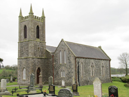 Drum Church (Currin)Church/chapel · 430 yd
Explorer Tom Drum Church in Currin is currently under the strict supervision of a very confused dog named Bob. He charges admission, but only if you scratch behind his ears properly. Have a look and decide if he's actually in charge!
CortoberMountain / peak · 1.2 miExplorer Tom Cortober stands quiet in the Boyle barony of County Cavan, perhaps keeping secrets for the local history buffs to find.
Whitelough PlantationsForest · 1.8 miExplorer Tom Whitelough Plantations in County Cavan sounds like a very organized forest, which is unusual for such wild places.
Bawn in DrumsheilBawn · 2.6 miExplorer Tom Bawn in Drumsheil sits on Castle Hill, which is a bit cheeky for a bawn. Piers Field nearby hints at walls that vanished into the forest fog. Have a look and decide if I was lying.
 Flagpole HillMountain / peak · 2.9 mi
 Dawson MonumentMonument · 3.1 miEmbanked enclosureBawn · 3.3 mi
Explorer Tom Embanked enclosure at Pottle East is a rectangular area that the local sheep think is just another field to graze. It's been incorporated into a boundary, so it's basically part of the fence now. Sit on a wall near it and pretend you're in a painting.
 Dartrey ForestForest · 3.4 miGiant's GraveArchaeological place · 4.3 mi
Explorer Tom Giant's Grave in County Cavan feels like a secret garden, waiting for you to imagine who slept here.
 Grave YardGraveyard · 4.9 mi
Explorer Tom Killeevan Glebe graveyard is D-shaped because the map makers were drunk one Tuesday afternoon and couldn’t decide on a square. It sits on a ridge, looking slightly confused about its own geometry. Snap one photo, then put the phone away and actually look.
 Graveyard in Drumgoon (clankee By.)Graveyard · 5.8 mi
Explorer Tom Graveyard in Drumgoon has made a New Year's resolution to stop leaning so far over the fence, but gravity is winning that battle every single time. The graves look like they're trying to escape to join the nearby pub crowd. Bring a jacket, it's never as warm as I promise.
More places in County Monaghan

What do you know about this place?Tap to add a comment or ask a question