Places near here
Photo credits
- Aubrey Dale, Wikimedia Commons · CC BY-SA 2.0
- Golfing in Ireland; photographer not stated, Source publisher
- Oliver Dixon, Geograph · CC BY-SA 2.0
- Eric Jones, Geograph · CC BY-SA 2.0
- Oliver Dixon, Wikimedia Commons · CC BY-SA 2.0
- Oliver Dixon, commons.wikimedia.org
- Rossographer, Geograph · CC BY-SA 2.0
- Rossographer, Wikimedia Commons · CC BY-SA 2.0
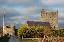 Kirkistown CastleCastle · 2.9 mi
Explorer Tom Kirkistown Castle is pretending to be from 1500, but I’m calling its bluff; it looks like a weekend DIY project that…
Tower-house and bawn: kirkistown castle in KirkistownTower-house and Bawn: Kirkistown Castle · 2.9 miExplorer Tom Kirkistown castle in Kirkistown got lost by the Vikings, who were clearly not great with directions back then. It’s the…
 Kirkistown Castle Golf ClubGolf course · 3.2 mi
 Burial IslandIslet · 4.0 mi
Explorer Tom Burial Island in County Down is off Burr Point, which is the easternmost point of Ireland, so it’s basically the edge…
 Kearney Coastal Walk, KearneyWalking route · 4.1 mi
Explorer Tom Kearney Coastal Walk is where the oystercatchers hold court and judge your outfit. Locals swear a poet once wrote a…
 Burr PointHeadland · 4.1 mi
Explorer Tom Burr Point claims Ireland's easternmost mainland title, and I can already hear Cannon Rock offshore objecting. The…
 Mitchel Park, John Mitchel's GAA, BallygalgetGAA ground · 4.4 mi
 Windmill HillMountain / peak · 4.6 mi
Explorer Tom This Windmill Hill started because two lads made a bet in the pub that they could find a hill with no wind, which…
 Glastry Presbyterian ChurchChurch · 5.1 mi
Explorer Tom Glastry Presbyterian Church bragged about surviving a storm that took out the roof of the pub next door but left its…
 Two Early Christian Churches: Churches of Dere in DerryTwo Early Christian Churches: Churches of Dere · 5.7 mi
Explorer Tom Two Early Christian Churches: Churches of Dere in Derry has a New Year's resolution to stop leaning so much. Two…
 Pherson's IslandIsland · 5.9 mi
Explorer Tom Pherson's Island is technically a drumlin that got promoted to island status after the sea level rose, which is like…
 Church & Graveyard & Coffin Lids (2): Ardkeen Church in ArdkeenChurch & Graveyard & Coffin Lids (2): Ardkeen Church · 6.0 mi
Explorer Tom Church & Graveyard & Coffin Lids (2): Ardkeen Church in Ardkeen has seagulls who critique its architecture from above…
More wrecks and historic events in County Down · All of County Down

What do you know about this place?Tap to add a comment or ask a question