What is recorded here
Modern church on site. No surface remains of medieval church (OF018-003001-) in the graveyard. Church shown in this area on Down Survey (1655-6) map. A Protestant church of 18th-century date now stands on the foundations of an earlier church of which there is no remains. (Comerford 1883, 305)
Test-trenching was carried out as part of the planning schedule by John Purcell under licence No. 05E0093 for a single-house development adjacent to a church and graveyard at Ballycommon, Tullamore. A series of trenches were excavated by mechanical digger at the house site, entrance and percolation area. No features or finds of archaeological significance were revealed.
From the National Monuments Service (Archaeological Survey of Ireland) record OF018-003002
The monument record does not grant public access. Check the route and ask the landowner before entering private land.
- What survives
- Recorded monument
Places near here
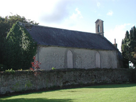 Saint Francis's Church (Ballycommon)Church/chapel · 20 ydEnclosure in BallycommonEnclosure · 671 yd
 Ballycommon BridgeBridge · 1288 ydEnclosure in RathdrumEnclosure · 1384 ydCastleCastle, unclassified · 1725 ydChildren's WellSpring · 1.7 miLady's WellSpring · 1.7 miCastleCastle, motte · 2.2 miBracklin WoodWood · 3.4 mi
 Father BurbageMemorial · 4.4 mi
 Grand Canal WayWalking route · 4.5 mi
 Croghan HillMountain / peak · 5.3 mi
Pictures: National Inventory of Architectural Heritage; JP, Geograph · CC BY-SA 2.0; Trenchspike, Wikimedia Commons · CC BY-SA 4.0; Sarah777 at en.wikipedia, Wikimedia Commons · Public domain
More memorials and graveyards in County Offaly · All of County Offaly
What do you know about this place?