
Places near here
Photo credits
- National Inventory of Architectural Heritage
- Offdaw, Wikimedia Commons · CC BY-SA 4.0
- Sitomon, Wikimedia Commons · CC BY-SA 2.0
- Kieran Campbell, Geograph · CC BY-SA 2.0
- Christian Pirkl, Wikimedia Commons · CC BY-SA 3.0 at
- Kieran Campbell, Geograph · Creative Commons Attribution-ShareAlike 2.0
- Jonjobaker, Wikimedia Commons · CC BY-SA 4.0
- C O'Flanagan, Wikimedia Commons · CC BY-SA 2.0
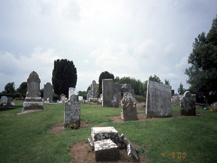 graveyard/cemetery8 yd
Explorer Tom Graveyard in Tobertown thinks the road leading to it is too flashy for its medieval taste. It has cut stone markers from 1750 onwards, mostly judging anyone who parks on the grass. It's free, it's odd, what more do you want? Just a bit of respect.
 Church in ruinsChurch · 17 yd
Explorer Tom Church in Tobertown is down to grass-covered foundations with just a few corner fragments left standing. It was in good repair until 1830, but now it’s mostly gone. The northwest corner has been stabilised, so check that out!
 European Yew1.1 mi
Explorer Tom This European Yew in Meath apparently gave up red berries for Lent to show off its spiritual side. It’s still full of itself though, don’t let the quiet fool you. Great spot to propose. Or at least to propose lunch.
 Gormanston CastleCastle · 1.2 mi
 Sycamore1.3 mi
 HarbourQuay · 1.7 mi
Explorer Tom Harbour in Knocknagin was built in 1760, and a diary from 1806 mentions moving a huge stone with two horses. It’s a ruined quay wall below Lowther Lodge. Ten minutes here and you'll have a yarn for the pub about heavy lifting.
 Bremore CastleCastle · 1.9 mi
Explorer Tom Bremore Castle in County Dublin was once a big deal for the Barnewalls but now it's basically a fancy ruin. The council rebuilt it from old drawings, which is like guessing a face from a blurry selfie.
 Quay in BremoreQuay · 2.1 mi
Explorer Tom Quay in Bremore: A stone pier at Newhaven is all that remains now, just a line of stones on the headland. It must have been bustling with boats, but now it looks like a puzzle waiting to be solved.
 Balrothery Heritage CentreMuseum · 2.9 mi
Explorer Tom Balrothery Heritage Centre in County Dublin is all about local history, so dig around for some old stories and pretend you’ve read the whole county archive on your phone.
 Séamus EnnisStatue · 3.1 mi
Explorer Tom Séamus Ennis is blowing a tune that nobody wants to hear in County Dublin. I bet he’s up to something dodgy. Wave at the flute and see if he waves back, or just run.
 Seamus Ennis Cultural CentreMemorial · 3.1 mi
Explorer Tom The Seamus Ennis Cultural Centre in County Dublin opened in 2001 to celebrate a piper who knew his stuff. I bet the music inside is loud. Go get some tunes for me!
 KnockbrackMountain / peak · 3.3 mi
Explorer Tom Knockbrack has a trig station on top for handy navigation. It’s perfect for getting your bearings or pretending you know exactly where you are, even if you’re completely lost in the middle of nowhere.
More archaeology and monuments in County Dublin · All of County Dublin

What do you know about this place?Tap to add a comment or ask a question