
What is recorded here
Situated in an elevated position at roadside W of village. Grass-covered foundations of church survives with nave (int. dims. L 20m, Wth 8m, wall T 0.8m) and chancel (int. dims. L 9m, Wth 6m, wall T 0.8m), orientated NNE-WSW. Fragments of NE and NW corners of nave survive (H 3m). Built of coursed limestone masonry. This parish church of Balscadden was in 'good repair' in 1630 but in ruins by 1887 (Walsh 1888, 251). A holy well lies SSW of church (DU001-003003-). Graveyard attached (DU001-003002-). On inspection in 2010 it was found that while some grass-covered mounding was still visible, the nave and chancel as described in the 1992 inspection are no longer dicernible. The north-west corner fo the church is extant and has been stabilised and repaired (6.5m EW x 2mNS x 3m h.). Both the north-east (3m Ew x 2m NS x 0.75m h.) and south-east (2m EW x 1.5m NS x 0.6m h.) corners are also extant but have been added to with stone and cement to form the limits of the Dunne family plot.
Situated in an elevated position at roadside W of village. Grass-covered foundations of church survives with nave (int. dims. L 20m, Wth 8m, wall T 0.8m) and chancel (int. dims. L 9m, Wth 6m, wall T 0.8m), orientated NNE-WSW. Fragments of NE and NW corners of nave survive (H 3m). Built of coursed limestone masonry. This parish church of Balscadden was in 'good repair' in 1630 but in ruins by 1887 (Walsh 1888,…
From the National Monuments Service (Archaeological Survey of Ireland) record DU001-003001
The monument record does not grant public access. Check the route and ask the landowner before entering private land.
- What survives
- Recorded monument
Places near here
Photo credits
- National Inventory of Architectural Heritage
- Sitomon, Wikimedia Commons · CC BY-SA 2.0
- Kieran Campbell, Geograph · CC BY-SA 2.0
- Kieran Campbell, Geograph · Creative Commons Attribution-ShareAlike 2.0
- Jonjobaker, Wikimedia Commons · CC BY-SA 4.0
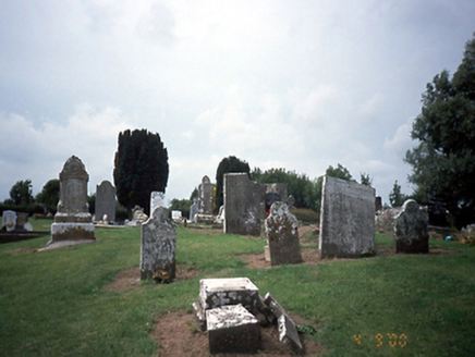 graveyard/cemetery10 yd
 Balscaddan HouseHouse · 221 yd
 European Yew1.1 miEuropean Yew1.1 mi
 Gormanston CastleCastle · 1.1 mi
 Gormanston CastleHouse, fortified house · 1.2 mi
 HarbourQuay · 1.7 mi
 Quay in BremoreQuay · 2.1 mi
 Balrothery Heritage CentreMuseum · 2.9 mi
 Seamus Ennis Cultural CentreMemorial · 3.1 mi
 KnockbrackMountain / peak · 3.3 mi
 Hollywood GreatMountain / peak · 4.2 mi
More historic places in County Dublin · All of County Dublin
What do you know about this place?