What is recorded here
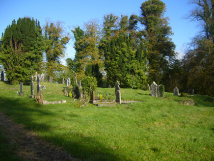
Ovoid area (c. 60m NW-SE; c. 50m SW-NE) enclosed by much-collapsed ivy-clad stone wall, and entered via short tree-lined avenue from road to S; entrance on road wrought-iron gate with ashlar piers. Burial plots concentrated at S end and date from mid-19th century. Near N end is low briar-covered platform (8.8m N-S; 20.5m E-W) where C of I church, built in 1822, was demolished in 1958 (Spellissy 1989, 239); short section of low wall (max. H 1.1m; L 4.55m) at NW corner all that now stands of this church. Unclear whether this site of church of Capella Russell which may date back to 15th century (Westropp 1904-5, 387), though Chapel Russel not made a separate parish until early 1980s (Spellissy ibid.).
Ovoid area (c. 60m NW-SE; c. 50m SW-NE) enclosed by much-collapsed ivy-clad stone wall, and entered via short tree-lined avenue from road to S; entrance on road wrought-iron gate with ashlar piers. Burial plots concentrated at S end and date from mid-19th century. Near N end is low briar-covered platform (8.8m N-S; 20.5m E-W) where C of I church, built in 1822, was demolished in 1958 (Spellissy 1989, 239); short…
From the National Monuments Service (Archaeological Survey of Ireland) record LI011-030002
The monument record does not grant public access. Check the route and ask the landowner before entering private land.
- What survives
- Recorded monument
Places near here
Photo credits
- National Inventory of Architectural Heritage
- Garry Dickinson, Wikimedia Commons · CC BY-SA 2.0
- Liam, Geograph · CC BY-SA 2.0
- Miguel Angel Masegosa Martínez, Wikimedia Commons · CC BY 2.0
- Peter Gerken, Wikimedia Commons · CC BY-SA 2.0
- Dieglop, Wikimedia Commons · CC BY-SA 4.0
- Joseph Mischyshyn, Geograph · Creative Commons Attribution-ShareAlike 2.0
 Pallaskenry Church (Chapelrussell)Graveyard/cemetery · 20 yd
 Coláiste SailíseachCountry house, church/chapel · 555 ydIndicatedEnclosure · 731 yd
_-_geograph.org.uk_-_6538081.jpg/250px-Castles_of_Munster,_Shanpallas,_Limerick_(1)_-_geograph.org.uk_-_6538081.jpg "Photo: Garry Dickinson, Wikimedia Commons · CC BY-SA 2.0") Shanpallas CastleCastle · 1149 yd
Shanpallas CastleCastle · 1149 yd Castle (in ruins)Castle, tower house · 1169 yd
 Sweet Chestnut1.2 miSweet Chestnut1.2 miRingmoylan PierVisitor information · 2.0 miMellon PointHeadland · 2.2 mi
 Curraghchase Forest ParkForest · 3.1 mi
 Bunratty CastleHouse · 4.1 mi
 Graveyard4.1 mi
More archaeology and monuments in County Limerick · All of County Limerick
What do you know about this place?