What is recorded here
Situated on an E-facing slope with extensive views of the surrounding area. Marked on the 1907 OS 6-inch map as a D-shaped or subtriangular enclosure (max. dims. 55m E-W; 55m N-S). Mentioned in OS Letters (O'Flanagan 1928, 82). The graveyard has recently been extensively cleared and the tombstones re-erected. The earliest legible tombstone is dated 1739. There is no trace of a church.
The above description is derived from the published 'Archaeological Inventory of County Wicklow' (Dublin: Stationery Office, 1997). In certain instances the entries have been revised and updated in the light of recent research.
Date of upload/revision: 17 December 2008
A portal dolmen; likely dating to the Neolithic period. Its location and form suggest it was a significant ceremonial or burial site within a wider prehistoric landscape.
This remains an important historical record, but the official description says the monument is no longer visible or has been destroyed. The monument record does not grant public access. Check the route and ask the landowner before entering private land.
- What survives
- No visible remains or recorded as destroyed
Places near here
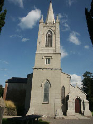 Saint Peter's Church (Kiltegan)church/chapel · 658 yd
 Humewood Castlegate lodge · 761 yd
 Chapel (in ruins), GraveyardChurch · 1101 yd
 Enclosure in GraigueEnclosure · 1273 yd
 IndicatedEnclosure · 1407 yd
 European BeechEuropean Beech · 1.2 mi
 Sessile OakSessile Oak · 1.5 mi
 CastleCastle, motte · 1.5 mi
 Keadeen MountainMountain / peak · 3.1 mi
 Sam McAllistair GraveMemorial · 3.1 mi
 MoatamoyCastle, motte · 3.4 mi
 Saint Brigit's ChairNamed rock · 3.5 mi