
What is recorded here
From the National Monuments Service (Archaeological Survey of Ireland) record CO144-032001
Places near here
Photo credits
- Maker not stated on source page, en.wikipedia.org
- National Inventory of Architectural Heritage
- Maker not stated on source page, it.pinterest.com
- Maker not stated on source page, www.the42.ie
- Picture: Echo Live
- Hywel Williams, Geograph · CC BY-SA 2.0
 Church in DunnycoveChurch · 32 yd
Explorer Tom Church in Dunnycove has no record uploaded, so I’m betting the rabbits think it’s just a fancy burrow entrance. Stand…
 Galley Head Signal TowerSignal tower · 186 yd
Explorer Tom Galley Head Signal Tower is missing its top story and looking a bit confused. The British forgot about the fog when…
 Farrah HouseHouse · 224 yd
Explorer Tom Farrah House in Ballyluck is a Gothic-Revival gem from 1860. It looks small but has a basement, so it’s bigger than it…
 Fairy fort / earthen ringfort in Balteenbrack (ibane and Barryroe By., Island Par.)Fairy fort / earthen ringfort · 393 yd
Explorer Tom Fairy fort in Balteenbrack had part of its bank removed during road widening, which is what happens when you argue with…
 telephone box465 yd
Explorer Tom Telephone box in Ballyluck is the only thing in this neighborhood that hasn’t been upgraded since the Bronze Age. It’s…
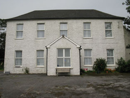 Ballyva HouseFarm house · 958 yd
Explorer Tom Ballyva House is a square plan farmhouse from around 1800 that’s had a bit of a renovation. It has a gabled porch…
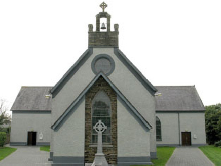 St James' Roman Catholic ChurchChurch/chapel · 1098 yd
Explorer Tom St James' Roman Catholic Church in Carhoo is having a dramatic falling out with the nearest tree, arguing over whose…
Fairy fort / earthen ringfort in Corrabally (ibane and Barryroe By., Kilkerranmore Par.)Fairy fort / earthen ringfort · 1286 ydExplorer Tom Corrabally (Fairy fort / earthen ringfort) in County Cork is heavily overgrown, which means the fairies have definitely…
 St. James' GAA pitchGAA ground · 1289 ydFairy fort / earthen ringfort in Brownstown (ibane and Barryroe By.)Fairy fort / earthen ringfort · 1388 yd
Explorer Tom Fairy fort / earthen ringfort in Brownstown holds a fake world record for being the tallest dirt mound that nobody…
 Red StrandBeach / strand · 1.4 mi
Explorer Tom Red Strand lies beyond Ardfield on the coast south of Clonakilty, tucked between green headlands as though West Cork…
 Galley HeadViewpoint · 2.7 mi
Explorer Tom Galley Head would post on social media: 'Another day of wind blowing my hair back, look how majestic I am…
More archaeology and monuments in County Cork · All of County Cork

What do you know about this place?Tap to add a comment or ask a question