What is recorded here
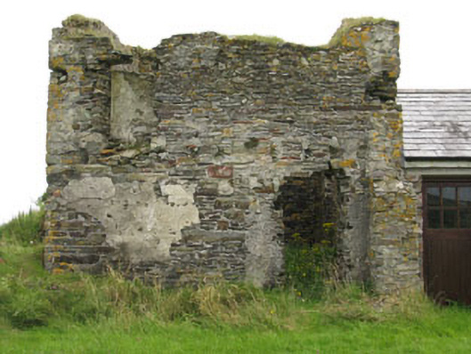
Freestanding two-bay two-stage square-profile signal tower, built c.1805. Now ruinous with upper stage missing, having later two-bay single-storey addition to side (west). L-plan stairwell to side (east) and rear (south) elevations, formerly granting access to upstage door opening (now absent). Roof missing to tower, pitched slate roof to side addition, having timber-clad eaves course and uPVC rainwater goods. Rubble stone walls throughout, having intermittent sections of roughcast render and slate hanging. English bond red brick parapet wall to stairwell. Cast-iron tie beams to sides (east, west) with bolts visible to side (east) elevation. Square-headed window openings throughout with dressed limestone voussoirs to tower, sills now absent. Red brick block-and-start surround and voussoirs to addition having timber-framed three-pane casement window. Square-headed door openings to tower, surrounds in poor state with lintels absent. Square-headed door openings to addition having red brick surround and replacement glazed timber and double-leaf timber battened doors. Former window and door openings visible to interior having stone voussoirs. Red brick hearth to interior of front wall. Ruinous outbuilding to south-east, having remains of rubble stone walls with sections of roughcast render. Recent four-bay single-storey former outbuilding to south-west, renovated and in use as house. Located on and elevated site with rubble stone enclosing wall. Square-profile gate piers with rubble capping to west of site.
One of an extensive network of signal towers which was built along the Irish coast in anticipation of an invasion by the French. However, the system was doomed to failure, as the British had not taken the wet and misty climate of the west coast into consideration, which obscured the signals.
From the Buildings of Ireland (National Inventory of Architectural Heritage) record 20914417
This does not grant access. Most recorded buildings are privately owned; view them only from public ground unless the owner allows entry.
Places near here
Photo credits
- National Inventory of Architectural Heritage
- Warren Buckley, Geograph · CC BY-SA 2.0
- Hywel Williams, Geograph · CC BY-SA 2.0
- Mike Searle, Geograph · CC BY-SA 2.0
- Wsiegmund, Wikimedia Commons · CC BY 2.5
- Jonathan Pascall, Geograph · CC BY-SA 2.0
- Neville Goodman, Geograph · CC BY-SA 2.0
- Caitlin Ferguson-Mir, Wikimedia Commons · CC BY-SA 2.0
- PAUL FARMER, Geograph · CC BY-SA 2.0
- Kenneth Allen, Geograph · CC BY-SA 2.0
- Hywel Williams, Wikimedia Commons · CC BY-SA 2.0
 Farrah HouseHouse · 366 yd
 telephone box535 yd
 Inchydoney BeachBeach / strand · 2.7 mi
 Galley HeadViewpoint · 2.8 mi
 Castle Freke WoodsForest · 2.8 mi
 Sitka Spruce3.0 mi
 Inchydoney BeachBeach / strand · 3.3 mi
 Clonakilty HarbourBay · 3.8 mi
 Ownahincha Strand (West)Beach / strand · 4.0 mi
 Michael Collins StatueMonument · 4.1 mi
 Clonakilty Tourist OfficeVisitor information · 4.2 mi
 Michael Collins MemorialMemorial · 4.4 mi
More historic places in County Cork · All of County Cork
What do you know about this place?