
Places near here
Photo credits
- Daniel Waters, Co. Sligo, Ireland from Ireland, Wikimedia Commons · CC BY 2.0
- National Inventory of Architectural Heritage
- Oliver Dixon, Geograph · CC BY-SA 2.0
- Rob Hurson, Wikimedia Commons · CC BY-SA 4.0
- Jon Sullivan, Wikimedia Commons · Public domain
- Gavigan 01 at English Wikipedia, Wikimedia Commons · CC BY 2.5
- Wikimedia Commons contributor · CC BY 2.5
- Kieran Campbell, Wikimedia Commons · CC BY-SA 2.0
 Ballinafad CastleCastle · 1142 yd
Explorer Tom Ballinafad Castle in County Sligo has strict house rules that include no shoes, no talking, and definitely no asking why it looks so confused on the map. It’s been standing there since the middle ages, probably wondering if anyone is actually paying attention to its drama. It's free, it's odd, what more do you want?
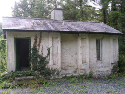 Hollybrook HouseGate lodge · 1561 yd
Explorer Tom Hollybrook House gate lodge in Aghanagh has pilasters so eccentric the rabbits think it’s a fancy burrow entrance. John ffolliott built it to show off how much money he had, and the gabled roof proves it. The rabbits are probably taking notes on your outfit as you walk past.
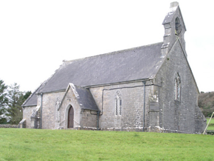 Aghanagh ChurchChurch/chapel · 1693 yd
Explorer Tom Aghanagh Church in Cuilsheeghary More has strict rules: no smartphones, no talking, and absolutely no one wearing bright orange. Joseph Welland designed it back in 1850 with sparrow-pecked stone that looks like it’s been chewed on. Pack a picnic for the graveyard, not the pews.
 Loughbrick BayBay · 2.1 mi
Explorer Tom Loughbrick Bay in County Sligo would tell you after a few pints that it actually swallowed a boat once but gave it back because it didn’t taste right, which is plausible. The water has a certain confidence about it, like it knows exactly where the bottom is and isn’t telling anyone else. Bring sandwiches, the gulls will thank you.
 Bricklieve MountainsMountain / peak · 2.3 mi
Explorer Tom The Bricklieve Mountains have had so many names they should really be asking for a royalty check. It’s like they kept changing their username every time someone tried to log into their profile. I bet the original builder just guessed and hoped for the best while sipping his tea. Wave at the cows, they're the real locals.
 Carrowkeel neolithic siteArchaeological place · 2.4 mi
Explorer Tom Carrowkeel sends you into Sligo's Bricklieve Hills to meet monuments that were old before most of our stories began. The passage tombs were built in the fourth millennium BC, overlooking Lough Arrow. Excavators came in 1911 and found remains and pottery; one distinctive pottery type became known as Carrowkeel Ware. Their Bronze Age date was wrong, though. Later research placed use of these tombs around 3500 to 2500 BC. I get a date wrong at dinner and hear about it for weeks; archaeology at least has the sense to correct itself. The old excavations also removed human remains, so the place is more than an ancient puzzle laid out for our entertainment. These are protected monuments on open hills, reached on foot over uneven ground. Check local access and weather, and leave the chambers and stones exactly as you found them. I'll keep my theories to the path, where they cannot loosen anything.
 Battle of the Curlew Mountains (1599)Battlefield · 2.7 mi
Explorer Tom The Battle of the Curlew Mountains has a family tree consisting entirely of angry men with sticks and bad decisions. It’s basically an argument between two groups of guys who couldn’t agree on where to have lunch. Grand place for a sulk or a snog, completely your call.
Battle of the Curlew MountainsBattlefield · 2.7 miExplorer Tom Battle of the Curlew Mountains is where a dog named Buster is currently in charge, barking orders at the clouds and the sheep alike. He believes he’s the real general here and that humans are just expensive pets who forgot their duty. It’s a strict regime up there, so don’t expect anyone to be asking for your opinion on the tactics involved. Make up your own legend and I'll swear it's true.
 Ballindoon Castle (in Ruins)Castle, unclassified · 3.0 mi
Explorer Tom Ballindoon Castle sits on a steep slope where the ground drops eight metres straight into Lough Arrow. The shortcut down there is definitely not a shortcut if you slip. Tell it a joke, it's been a long time since anyone did.
 Curlew MountainsMountain / peak · 3.7 mi
Explorer Tom The Curlew Mountains may have nothing to do with curlew birds, which is awkward because I had prepared a terrific imitation. Their name likely grew from Irish words for rugged, pointed hills. Between Boyle and Castlebaldwin, hard sandstone and conglomerate rise above softer limestone country, giving this modest range its shape. The Battle of Curlew Pass took place here in 1599, a serious chapter that deserves a straight account. I would leave the bird call out of that story and use it only to annoy my travelling companion afterwards. Choose a lawful public trail or viewpoint, check local routes and weather, and treat any historic ground respectfully. Look at the ridgeline against the lower land. You can see why even these relatively low hills have long mattered.
 Hog's IslandIslet · 3.8 mi
Explorer Tom Hog’s Island in County Roscommon sounds like the place where pigs go to hide from the butcher, but it’s probably just a rock. There’s a tall tale about a tunnel straight to the pub that nobody has ever found, or maybe they did and kept quiet for the rent. Look for the ghost, then pretend you didn't.
 Giants GravePortal tomb · 3.9 mi
Explorer Tom Giants Grave in Carrickglass is the site of a ridiculous smuggling story involving cheese and a very large roofstone. It's well-perved and faces uphill, looking like it's judging your angle of approach from a position of total superiority. Have a sandwich here and call it a heritage lunch.
More archaeology and monuments in County Sligo · All of County Sligo

What do you know about this place?Tap to add a comment or ask a question