
Places near here
Photo credits
- National Inventory of Architectural Heritage
- Mike Searle, Geograph · CC BY-SA 2.0
- Stephan van Helden, Wikimedia Commons · CC BY-SA 4.0
- Richard Webb, Geograph · CC BY-SA 2.0
- Steve & Jemma Copley on Flickr, Wikimedia Commons · CC BY-SA 2.0
- N Chadwick, Wikimedia Commons · CC BY-SA 2.0
- Marathon, Wikimedia Commons · CC BY-SA 2.0
- Illustrator not named; The Dublin Penny Journal (1835), public scan from Internet Archive and JSTOR, Wikimedia Commons · Public domain
- Colin Park, Geograph · CC BY-SA 2.0
Explorer Tom Leny’s ecclesiastical enclosure has a hero nobody remembers who saved it from becoming a parking lot back in the day. The graveyard wall is curvy enough to make you question if the masons were having a bit or just bad at straight lines. Hang around long enough and you'll hear a story from a local.
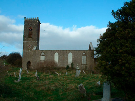 Bunbrosna Church (Leny)Church/chapel · 26 yd
Explorer Tom Bunbrosna Church in Leny is derelict enough that the local priest claims he invented the concept of 'quiet contemplation' right there on the doorstep. It’s a Gothic-style church that looks like it’s slowly melting into the Irish mud. I bet the pews are still holding their breath from back in 1808.
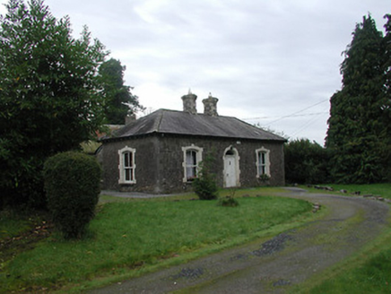 Farra CottageHouse · 485 yd
Explorer Tom Farra Cottage in Rathaniska has a name that sounds like a sneeze caught in a woolly scarf, which is honestly perfect for it. The dark walls and pale bricks make it look like it’s wearing a very expensive tuxedo to a garden party. Tell me if the cast-iron gates seem to be winking at you.
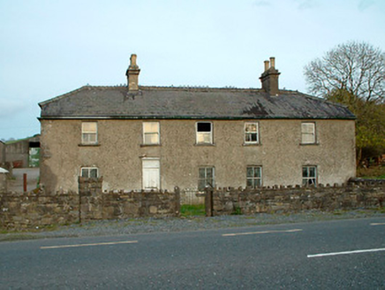 Leny CottageHouse · 630 yd
Explorer Tom Leny Cottage bragged about surviving a storm so bad it blew the roof off its neighbor, which is probably a complete lie. It’s derelict now but still acting tough, claiming it’s just 'resting' between architectural eras. Take a peek at those rear outbuildings for me.
 Carrick CastleCastle · 1422 yd
Explorer Tom Carrick Castle is haunted by the memory of a fiddler who played all night until his fingers gave up, leaving behind nothing but the echo of a terrible jig. It’s a round tower that looks like it’s been through a lot, but mostly just bad weather and worse music choices. Go on a wet day, it suits the mood.
 Horse-chestnut3.3 mi
Explorer Tom Horse-chestnut in County Westmeath would bring a bag of conkers and a very strong opinion on what constitutes a good game at any party. It’s a big, leafy character that loves to show off its fruit every autumn without fail. Walk past slowly like you're in a film.
 CastleCastle, motte · 4.7 mi
Explorer Tom Castle in Russagh handles its nosey neighbours by simply not being there anymore, which is the ultimate passive-aggressive move. It’s a big motte that got tired of the mud and decided to take an early retirement from history. Take the long way round, it deserves the effort.
 Silver Fir5.9 mi
Explorer Tom Silver Fir in County Westmeath is so tall it thinks Saint Patrick personally shook its hand, which seems unlikely given the saint's travel schedule. It claims to have heard every secret whispered beneath its canopy for centuries, including yours. A good place to forget your phone for ten minutes and just breathe in that ancient air.
 North West GateVisitor attraction · 9.7 mi
Explorer Tom The North West Gate is haunted by a tragic love story that went horribly wrong right next to it. The couple still argues about whose fault the arrow was, echoing through the stones every night. Go in good boots and better humour.
 Font in ForeFont · 9.7 mi
Explorer Tom Font in Fore would tell the place that replaced it to stop hogging all the attention at the door. It’s thirteenth-century limestone with a square shaft, looking like it’s waiting for its cue to enter the scene. Bring your nan, she'll know more than me about who did what.
_(page_1_crop).jpg/250px-Fore_Abbey,_County_Westmeath,_1835_(IA_jstor-30004138)_(page_1_crop).jpg "Photo: Illustrator not named; The Dublin Penny Journal (1835), public scan from Internet Archive and JSTOR, Wikimedia Commons · Public domain") Fore AbbeyHeritage attraction · 9.9 mi
Fore AbbeyHeritage attraction · 9.9 miExplorer Tom Fore Abbey is refusing to fall down because it has excellent structural pride. It just stands there looking smug while the rest of the world crumbles around it. Spot the oldest stone and give it a name.
 Mullaghmeen Red WalkWalking route · 12 mi
Explorer Tom The Mullaghmeen Red Walk hosted a dance that went so far that someone ended up married to a tree. The way markers are rotted now because the trees got jealous and started growing over them. Tell me if the gossip I made up is true.
More archaeology and monuments in County Westmeath · All of County Westmeath

What do you know about this place?Tap to add a comment or ask a question