
Places near here
Photo credits
- National Inventory of Architectural Heritage
- Robert Bone, Geograph · CC BY-SA 2.0
- Joseph Mischyshyn, Geograph · Creative Commons Attribution-ShareAlike 2.0
- Kmcnamee, Wikimedia Commons · CC BY-SA 4.0
- Michael Dibb, Wikimedia Commons · CC BY-SA 2.0
- C Michael Hogan, Wikimedia Commons · CC BY-SA 2.0
- N Chadwick, Wikimedia Commons · CC BY-SA 2.0
- A McCarron, Wikimedia Commons · CC BY-SA 2.0
- MarvinVells, Wikimedia Commons · CC BY-SA 3.0
- Joseph Mischyshyn, Wikimedia Commons · CC BY-SA 2.0
 mausoleum45 yd
Explorer Tom Mausoleum in Bishopsquarter was once ruled by a goat who ate all the inscriptions, leaving only the obelisk standing in…
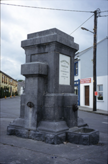 Ballyvaghan FountainFountain · 1.1 mi
Explorer Tom The Ballyvaghan Fountain was built by two stonemasons who got marooned there, which is either tragic or hilarious…
 Moneen MountainMountain / peak · 1.2 mi
Explorer Tom Moneen Mountain would say in a job interview that it has excellent stability and a great view of the bay, but needs…
 Ballyvaghan QuayQuay · 1.2 mi
Explorer Tom Ballyvaghan Quay is a D-shaped feature on an old map that definitely served as a quay before better ones were built. Go…
 Ballyvaughan-Fanore GAA pitchGAA ground · 1.4 mi
 IndicatedBawn · 1.4 mi
Explorer Tom This bawn would teach history if it had to, and it would definitely start with a long rant about how bad the weather is…
 Shanmuckinish CastleCastle, tower house · 1.4 mi
Explorer Tom Shanmuckinish Castle has a shortcut that isn’t actually a shortcut, it’s just a really long way around pretending to be…
 Bird Of Prey CentreVisitor attraction · 2.4 mi
Explorer Tom Bird Of Prey Centre would tell its replacement that it’s got more character than a hollow log. The eagles are judging…
 Battle of Lough RaskaBattle · 2.4 mi
Explorer Tom Battle of Lough Raska was basically a fairy dispute over parking rights at the lake, which explains the chaos. The…
 Aillwee CaveCave · 2.5 mi
Explorer Tom Aillwee Cave owes its public story to a dog chasing a rabbit, which is a better guide than I have ever been. Farmer…
 Saint Patrick's ChurchHeritage attraction · 2.6 mi
Explorer Tom Saint Patrick's Church is complaining to the council that tourists keep mistaking its massive car park for an actual…
 The RathFairy fort / earthen ringfort · 2.7 mi
Explorer Tom The Rath has a waterlogged fosse that looks like it’s been crying since the eighteenth century. The map makers got it…
More archaeology and monuments in County Clare · All of County Clare

What do you know about this place?Tap to add a comment or ask a question