
Places near here
Photo credits
- Algirdas at Lithuanian Wikipedia, Wikimedia Commons · Public domain
- National Inventory of Architectural Heritage
- Sitomon, Wikimedia Commons · CC BY-SA 2.0
- Stefan Riesner, Wikimedia Commons · CC BY-SA 3.0
- Chmouel Boudjnah Original uploader was Chmouel at fr.wikipedia, Wikimedia Commons · CC BY-SA 3.0
- Andreas F. Borchert, Wikimedia Commons · CC BY-SA 4.0
- Mike Searle, Geograph · CC BY-SA 2.0
- Mike Searle, Wikimedia Commons · CC BY-SA 2.0
- Sarah777, transferred by Lvova, Wikimedia Commons · Public domain
Explorer Tom Site of Church in Ballybrada is completely invisible at ground level, which makes it the perfect place to pretend you found something really significant. A local Quaker set up the graveyard back in 1738 because he liked his own company more than anyone else’s. Best seen with a hangover and a sausage roll.
 Pedunculate Oak23 yd
Explorer Tom Pedunculate Oak in County Tipperary was planted by a builder who was really thinking about lunch rather than the soil composition at the time. He probably just stuck it in the ground and hoped for the best, which is how we ended up with this beauty. Leave nothing but footprints and a bad pun.
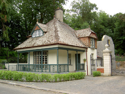 Ballybrada HouseGate lodge · 494 yd
Explorer Tom Ballybrada House in Ballybrada would post about its clay tiles on social media like they’re haute couture. The gate lodge thinks it’s the main event, not just the doorman. Imagine its Instagram caption: 'Just another day guarding the entrance to my ego.'
 European Yew1207 yd
Explorer Tom This European Yew in County Tipperary has a family tree that is mostly made up by people who wanted to sound important at dinner parties. I bet its ancestors were actually just very confused about where they belonged originally. Make up your own legend and I'll swear it's true.
 Swiss CottageCottage ornee · 1217 yd
Explorer Tom The Swiss Cottage has a cow that tried to buy it with a shiny coin, and now it’s stuck there. Built by Richard Butler as an architectural toy, it pitches its roof like it’s trying to dance. The balconies are humble, but the spirit is absolutely not.
Woodcock HillMountain / peak · 1.7 miExplorer Tom Woodcock Hill has a retirement plan that involves becoming a very expensive rock collection for rich people who don't know how to walk. It’s dreaming of a life where it doesn’t have to be climbed, just admired from a distance. Bring biscuits, every good story needs biscuits.
 Cahir CastleHeritage attraction · 1.9 mi
Explorer Tom I came to Cahir carrying a spade; the Suir did the work first. Cahir Castle sits in the River Suir as though someone decided a moat should come ready made. Its name remembers an older stone fort, or cathair, and the later castle grew through O'Brien and Butler hands into one of Ireland's great fortified piles. In 1599 the Earl of Essex took it after a three day siege; in 1650 it surrendered to Cromwell without a shot. I'd have offered to guard the gate, but the Butlers might have checked my references. That is quite a change in negotiating style for the same walls. The Butlers kept shaping the place, and part of the Great Hall was rebuilt in the 1840s, so what you see carries several periods at once. The state heritage service offers visits and guided information; check the current opening and tour arrangements before travelling. From the bridge, look at the towers rising out of the water and try to work out which approach you would have chosen. Sensibly, choose the visitor entrance.
Siege of Cahir CastleSiege · 2.0 miExplorer Tom The Siege of Cahir Castle happened when someone got really angry about walls and probably ran out of bread. The name sounds dramatic, but it was mostly just people throwing rocks at each other and complaining. The castle is still there, pretending it didn’t get a bit of chipping. Pick a stone, any stone, and invent its biography.
 Caher AbbeyHeritage attraction · 2.2 mi
Explorer Tom Caher Abbey in County Tipperary is secretly proud of one specific potato that grew near its wall and somehow survived the famine despite all odds. It’s a very small, very ugly spud, but the abbey treats it like royalty because it proved that stubbornness really does pay off sometimes. Wave at the cows, they're the real locals.
 Coolbane Castle (in ruins)Castle, tower house · 2.2 mi
Explorer Tom Coolbane Castle in Loughlohery was knocked down in the 1940s, so the rabbits have had eighty years to redecorate with their little droppings. The stone was carried off, probably by ghosts who really wanted to start a new life elsewhere. A good place to forget your phone for ten minutes.
_-_geograph.org.uk_-_1393369.jpg/250px-Castles_of_Munster_-_Ardfinnan,_Tipperary_(2)_-_geograph.org.uk_-_1393369.jpg "Photo: Mike Searle, Wikimedia Commons · CC BY-SA 2.0") Ardfinnan CastleCastle · 3.0 mi
Ardfinnan CastleCastle · 3.0 miExplorer Tom Ardfinnan Castle is built like Saint Patrick would have designed it, which means it’s all about showing off and hoping no one notices the cracks. It’s been guarding that river crossing since before we had proper shoes, so treat it with respect or get a boozer. Look for the ghost, then pretend you didn't.
 Knockgraffon MotteArchaeological place · 4.5 mi
Explorer Tom Knockgraffon Motte is furious because the map makers got its position completely wrong on the last survey. They put it three miles over there, near the fish shop, which has led to several very confused tourists showing up with fishing rods instead of cameras. Stand there long enough and someone will ask if you're lost.
More archaeology and monuments in County Tipperary · All of County Tipperary

What do you know about this place?Tap to add a comment or ask a question