DDiscover AloneMapAbout

Graveyard in Ardfert

Graveyard
Computer-made picture that does not show Graveyard in ArdfertNot a photo of this monument
Computer-made picture. It does not show this monument. · Report the wrong picture

What is recorded here

Ardfert graveyard was surveyed and described by Laurence Dunne in 2012 as follows; 'The early Medieval monastic complex of structures, cathedral and graveyard is situated on the northern limits of the village Ardfert circa 8 km north of Tralee. The complex includes the excavated and conserved ruins of a medieval…

Read the whole record
Ardfert graveyard was surveyed and described by Laurence Dunne in 2012 as follows; 'The early Medieval monastic complex of structures, cathedral and graveyard is situated on the northern limits of the village Ardfert circa 8 km north of Tralee. The complex includes the excavated and conserved ruins of a medieval cathedral [KE020-046002-] whose chronology extends between the 11th to the 17th centuries. There are two other extant structures including the 12th century church known as ‘Templenahoe’ [KE020-046007-] and a later 15th century church called ‘Templenagriffin’ [KE020-046001-] that has been recently conserved and restored. The complex also contained a 36m high round tower [KE020-046003-] that collapsed in 1771. A few in situ stones corresponding to the basal courses of the round tower are still discernible today as well as a number of ex situ ones scattered around the immediate area. A 19th century tomb (No. 38) partially extends over the round tower site (Barrington 1976, 252). The cathedral was fully excavated by Fionnbarr Moore, senior archaeologist with the NMS, over a seven year period in tandem with major conservation works carried out by Grellan Rourke of the OPW. These works have now been completed and Ardfert cathedral is now a managed visitor centre open to the public. All excavated interments in the cathedral were reburied in the newer section of the graveyard abutting the old one at the east. Three entrances are available-two of which lead into the old graveyard area that encompasses the historic churches and cathedral while the third leads directly into the newer graveyard section abutting the older one at the east end. There is another separate entrance into the visitor centre via the main door of the south transept directly from the kerbside. A high iron gate is set between two square limestone piers at the SE end of the south boundary wall a little to the east of the south transept. A modern galvanised gate provides access into the western area of the graveyard and is in good order. Entrance into the newer graveyard area is provided for by a pair of iron gates in poor order, neglected and rusted. The gates are set between a pair of solid square limestone piers with ‘soldier’ capping. Abutting the east pier is a squeeze-stile made from slate. The southern boundary wall extending west from the south transept is circa 1.8m high and is constructed with rubble limestone bonded in mortar with the mid section laid to courses. The west limits of the graveyard is enclosed buy a stone wall outside of which and abutting the OPW use as a works depot. There is a breach in the north-west corner of the wall. The east party wall between the old and lower newer graveyard is uncapped and virtually covered in ivy. The north boundary parallel to the cathedral is constructed with rubble limestone and is in general good order although ivy has established itself. Further west the area around the two churches is enclosed by a modern green chain-link fence. The lower newer graveyard is enclosed by a low rubble limestone wall with rounded cement capping along its south-east and northern limits. A strong growth of ivy has established itself along the north and north-eastern sections of the wall. There are eighty-eight, (88), tombs in Ardfert graveyard. The vast majority of which (80) are situated within the older medieval graveyard area. The tombs are the haunched ‘strong-box’ type as well as gabled house type as well. Only one tomb, TB60, contained a reused medieval masonry fragment comprising a chamfered limestone block, No. 18. A total of 224 named and generally modern headstones (HS) were recorded. The vast majority are modern and in good order and in the main are distributed across the newer graveyard area (circa 60%) to the east. However, in the older medieval area of the graveyard there are a number of very fine 18th and 19th century headstones that are very fine carved and decorated. There are 402 uninscribed rough unhewn gravemarkers dispersed throughout the older medieval graveyard with only five situated in the later newer graveyard area to the east. A total of twenty-seven (27) horizontal graveslabs were recorded at Ardfert. There are twenty (20) architectural fragments in Ardfert graveyard. The vast majority (13) are clustered together both in situ (3) and ex situ (10 ) associated with the round tower that collapsed in 1771. One of the masonry fragments (AF 1) is painted white and comprises a section of a 15th century window mullion and stands within a formal graveyard immediately inside the west entrance gateway beside the pathway. A single holed or perforated unnamed gravemarker was recorded in the old graveyard area a little to the west of the south transept' (Dunne 2012, 3-11).

From the National Monuments Service (Archaeological Survey of Ireland) record KE020-046011

The monument record does not grant public access. Check the route and ask the landowner before entering private land.

What do you know about this place?Tap to add a comment or ask a question

What you write will be public.

Places near here

Photo credits
  • JohnArmagh, Wikimedia Commons · Public domain
  • National Inventory of Architectural Heritage
  • Jonathan Thacker, Geograph · CC BY-SA 2.0
  • Colin Park, Geograph · Creative Commons Attribution-ShareAlike 2.0
  • Adrian Platt, Geograph · CC BY-SA 2.0
  • Colin Park, Geograph · CC BY-SA 2.0
  • Cathy Cox, Geograph · CC BY-SA 2.0
Site of Round TowerRound tower · 35 yd

Explorer Tom Site of Round Tower in Ardfert wants its tombstone to say 'I fell over, not because I was weak.' The stones are scattered, but the memory is tall and proud. Leave nothing but footprints and a bad pun.

Ardfert CathedralHeritage attraction · 53 yd

Explorer Tom Ardfert Cathedral has three ruined churches on one site, which is generous of Kerry and a challenge to my habit of calling every wall by the same name. The main cathedral grew from the twelfth century after Ardfert became a diocesan seat by 1117. Saint Brendan is linked with an older monastery here, though the standing stones belong to later builders. Smaller church ruins and carved pieces share the ground with burials, so this is no place for a noisy treasure hunt. I would ask you to count the buildings first, then let the guide explain which century goes where. Check current heritage-site entry and opening times, use marked paths and treat memorials and old masonry respectfully. Take a slow look at the main church from outside. It carries far more changes than its first outline suggests.

15th Centenary of the birth of St-BredanMemorial · 91 yd

Explorer Tom Fifteen centuries is a long time to wait for a birthday party, yet St Bredan’s memorial in Kerry seems to have forgotten its own date. It looks less like a celebration and more like a confused stone that got left behind at the pub. Look for the ghost, then pretend you didn't.

Statue of Roger CasementMemorial · 200 yd

Explorer Tom Statue of Roger Casement in County Kerry has a long-standing grudge with the local weather for always making him look wet and miserable. He's done more for Ireland than most people who actually vote, so give him some grace. Whisper a secret at it, it's kept worse.
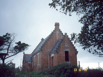
Ardfert Parish RoomChurch hall/parish hall · 209 yd

Explorer Tom Ardfert Parish Room is sitting there with its crow-stepped gables looking like a sad staircase. A poet fell in the ditch nearby, allegedly for poetic inspiration, or just bad luck. Toast it with a cup of tea and move on to the next.

Talbot-Crosbie Memorial FountainMonument · 236 yd

Explorer Tom The Talbot-Crosbie Fountain holds a fake world record for being the most smug stone plinth in Ardfert. It thinks it invented water pressure just to show off its 1901 badge. Visit, then text me what you think. I'll pretend to read it.

Saint Brendan's Catholic ChurchChurch/chapel · 248 yd

Explorer Tom Saint Brendan's Catholic Church in Ardfert would order extra chips with its fish and chips, no question asked. It’s a solid 1855 Gothic Revival gem that looks like it could survive a minor earthquake. Bring a notebook and write the bit I made up.

Ardfert FriaryVisitor information · 637 yd

Explorer Tom Ardfert Friary has been locked in a decades-long feud with the rain, claiming it’s not leaking but just expressing artistic emotion through the roof tiles. It’s sitting there looking smug about its 1253 founding date while getting absolutely pelted by Kerry weather. Pop by and tell it it's looking well.

Ardfert Franciscan FriaryVisitor information · 665 yd

Explorer Tom Ardfert Franciscan Friary is hosting an exclusive celebrity brunch that started in 1253 and never really stopped, featuring Thomas Fitzmaurice as the reluctant head chef. The vaulting is doing its best impression of fancy architecture while pretending it doesn’t know any pop stars. Tell me if the gossip I made up is true.

St. Brendans WellHoly well · 912 yd

Explorer Tom St. Brendans Well is so hidden under swamp that even the bishop refused to visit. It’s basically a holy puddle pretending to be something grander than it is. Have a look and decide if I was lying.

Rathoneen Castle (remains of)Castle · 1.7 mi

Explorer Tom Rathoneen Castle is basically a pile of rocks that thinks it’s a fortress, and honestly, I’m not arguing with that. The rabbits treat it like a personal playground, jumping over walls faster than you can blink. Bring wellies and low expectations, leave delighted.

CastleCastle, tower house · 1.7 mi

Explorer Tom Castle in Rahoneen was once home to a poet who fell in the ditch nearby. All that remains are the lower floors looking very confused at the sky. Find a local and ask them the real story, then come back and tell me.

More archaeology and monuments in County Kerry · All of County Kerry

Add to this placeAdd a picture Add a detailed tip Add a story

Explore the map1,093,392 places to discover

Next place · or swipeSite of Round Tower