
Places near here
Photo credits
- Mike Searle, Wikimedia Commons · Creative Commons Attribution-ShareAlike 2.0
- Thomas Thiele, Wikimedia Commons · CC BY 3.0
- Drow69, Wikimedia Commons · CC BY-SA 3.0
- Gordon Hatton, Geograph · Creative Commons Attribution-ShareAlike 2.0
- Andreas F. Borchert, Wikimedia Commons · CC BY-SA 4.0
- Mac McCarron, Geograph · Creative Commons Attribution-ShareAlike 2.0
- Robert Bone, Geograph · CC BY-SA 2.0
- Mac McCarron, Geograph · CC BY-SA 2.0
- MarvinVells, Wikimedia Commons · CC BY-SA 3.0
- N Chadwick, Wikimedia Commons · CC BY-SA 2.0
- PaulT, Wikimedia Commons · CC BY-SA 4.0
- C Michael Hogan, Geograph · CC BY-SA 2.0
_-_geograph.org.uk_-_4570444.jpg/250px-Castles_of_Munster,_Cappagh,_Clare_(1)_-_geograph.org.uk_-_4570444.jpg "Photo: Mike Searle, Wikimedia Commons · Creative Commons Attribution-ShareAlike 2.0") Cappagh CastleCastle · 1.9 mi
Cappagh CastleCastle · 1.9 miExplorer Tom Cappagh Castle smells like wet stone and old secrets, according to my very reliable nose, which is probably just damp moss doing its thing. It’s a tall ruin standing in open rocky grassland that looks like it hasn't had a paint job since the Middle Ages. Bring a coin for luck and keep it in your pocket.
_IRL_facing_cairn_view_WNW.jpg/250px-Turlough_Hill(clare)_IRL_facing_cairn_view_WNW.jpg "Photo: Thomas Thiele, Wikimedia Commons · CC BY 3.0") Turlough HillMountain / peak · 2.1 mi
Turlough HillMountain / peak · 2.1 miExplorer Tom Turlough Hill is effectively run by one very angry dog who barks at everyone who dares to look at its limestone pavement with anything other than pure reverence. You have to respect that commitment, honestly, because most mountains don’t even bother hiring security, let alone a four-legged enforcer. Go now, before it gets famous.
 Templecronan (in ruins)Church · 2.2 mi
Explorer Tom Templecronan survived a storm that broke the local boatman’s back, and it just shrugged it off. The cyclopean masonry is thick enough to block out bad news. Stand there long enough and someone will ask if you're lost.
 Holy Well2.6 mi
Explorer Tom Holy Well in Glencolumbkille South is tiny, but it claims to cure your eyes and feet, which sounds like a very specific package deal for people who walk too much. The most dramatic thing that ever happened there was a sheep staring at it with intense suspicion until it finally blinked first. Best seen with a hangover and a sausage roll.
 Oughtmama Church (in ruins)Church · 2.8 mi
Explorer Tom Oughtmama Church thinks the postman owes it a massive apology for all those missed deliveries over the centuries. It's the biggest of the bunch, acting like it runs the whole valley from its hilltop perch. Dare you to say hello to it out loud and see if it flinches.
 Grave YardGraveyard · 2.8 mi
Explorer Tom Graveyard in Glencolumbkille South has a carved stone head hiding in the wall. Legend says if you don't wave, you get cursed with bad socks. A good place to forget your phone for ten minutes flat.
 Moneen MountainMountain / peak · 3.5 mi
Explorer Tom Moneen Mountain would say in a job interview that it has excellent stability and a great view of the bay, but needs more funding for moss maintenance. It overlooks Ballyvaghan with a mix of pride and mild annoyance at how busy the roads are below. If it's closed, admire it from the road like a polite stalker.
 Castle in ruinsCastle, tower house · 3.6 mi
Explorer Tom Castle in ruins near Carran Turlough is secretly proud of the potato growing next to its foundation because the castle is doing worse. It controls a routeway but mostly just controls your sense of direction. Pretend it's yours and plan the housewarming.
 Aillwee CaveCave · 4.2 mi
Explorer Tom Aillwee Cave owes its public story to a dog chasing a rabbit, which is a better guide than I have ever been. Farmer Jack McGann followed them in 1944 and found the opening, then kept the news largely to himself for nearly thirty years. Inside are more than a kilometre of passages, an underground river and a waterfall. Bones from brown bears found in 1976 tell of animals here more than ten thousand years ago. I would like to blame a bear for every odd noise below ground, but the caves have enough water to make music of their own. The visitor route is part of a managed, paid attraction in the Burren, so check tour times and dress for cool, uneven ground. Do not wander beyond the guided path because my map ends at the daylight. Ask yourself what the dog thought it had found when the rabbit vanished.
 Bird Of Prey CentreVisitor attraction · 4.3 mi
Explorer Tom Bird Of Prey Centre would tell its replacement that it’s got more character than a hollow log. The eagles are judging your haircut right now, you can feel it. Bring the dog, it'll have opinions.
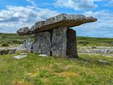 Poulnabrone DolmenHeritage attraction · 4.4 mi
Explorer Tom You see a tidy little stone sculpture? Those builders had a much heavier job. Poulnabrone Dolmen stands in the Burren like a stone doorway, but this was a burial place, not an invitation to walk through. The name means “Hole of the Quernstone”; “Hole of Sorrows” is a common mistranslation, however tempting it is for a dramatic storyteller. Today you see the stone skeleton. I can embellish a tale, but I cannot turn a quernstone into sorrow just by wishing. Its builders originally covered the chamber with earth and a cairn, so the familiar outline is only part of their design. The capstone rises toward the west, a detail worth noticing from the path. In the twentieth century a crack in a supporting stone kept widening, and careful work in 1986 and 1988 both secured the monument and revealed burials made over many generations. I will leave the people buried here their dignity and keep my jokes for my own poor sense of direction. The limestone ground is rough; stay on the visitor approach and leave the ancient stones untouched. They have carried enough weight already.
 The Portal TombVisitor information · 4.4 mi
Explorer Tom The Monastery of St. Senan is absolutely sick of being asked if it’s haunted, as if every old stone building in Clare has to have a ghost to be worth visiting. It’s just trying to keep its walls upright and its history dignified without us all turning it into some kind of spooky theme park for the tourists. Stick around for the light
More mountains and hills in County Clare · All of County Clare

What do you know about this place?Tap to add a comment or ask a question