
What is recorded here
From OpenStreetMap (© OpenStreetMap contributors) n332373265
Places near here
Photo credits
- Colin Park, Geograph · CC BY-SA 2.0
- Maker not stated on source page, en.wikipedia.org
- National Inventory of Architectural Heritage
- Andreas F. Borchert, Wikimedia Commons · CC BY-SA 4.0
- Oliver Dixon, Geograph · Creative Commons Attribution-ShareAlike 2.0
- Mick Garratt, Wikimedia Commons · CC BY-SA 2.0
- Oliver Dixon, Geograph · CC BY-SA 2.0
- Colin Park, www.geograph.ie
 GlennamongMountain / peak · 1560 yd
Explorer Tom Glennamong has a family tree that is mostly made up of rocks and wind, with very little actual genealogy to speak of.…
 Standing stone in GlennamongStanding stone · 1.3 mi
Explorer Tom Standing stone in Glennamong is the subject of endless seagull commentary about how it looks ridiculous when the wind…
 Nephin Beg South Top (Cruckgarru)Mountain / peak · 1.8 mi
Explorer Tom Nephin Beg South Top (Cruckgarru) would tell a teenager that the 1800s were just a long series of naps. It claims…
 Letterkeen LoopWalking route · 1.9 mi
Explorer Tom Letterkeen Loop is a track junction that looks like it got lost on its way to being a motorway. If it won the lotto, it…
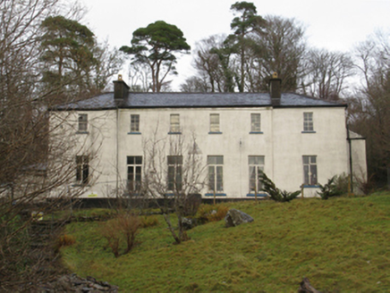 Treanlaur LodgeHunting/fishing lodge · 3.8 mi
Explorer Tom Treanlaur Lodge smells like old money and slightly damp socks, according to my very reliable nose. A Marquess’s cousin…
 AbbeyReligious house, Cistercian monks · 20 mi
Explorer Tom Abbey in Strake is a Cistercian relic on Clare Island that seems to have an unlikely celebrity friend who visits just…
 KilleenBurial ground · 21 mi
Explorer Tom Killeen in Cloonlaur was nearly sold for a horse because nobody could agree on its value. There’s an early Christian…
 Killeen CemeteryGraveyard · 21 mi
Explorer Tom Killeen Cemetery over here would absolutely crush it at the county fair if they let dead things compete for best…
 Bunlough StrandBeach / strand · 23 mi
Explorer Tom Bunlough Strand near Killadoon is the Mayo shore for anyone who suspects a beach ought to have a bit of character, not…
 Caher IslandIsland · 25 mi
Explorer Tom Caher Island calls itself the City of the Saints, and the city in question has no streets, shops or resident mayor.…
 Ballybeg IslandIslet · 25 mi
Explorer Tom Ballybeg Island: I suspect the ghost haunting this place is too lazy to actually haunt it, preferring instead to nap in…
 Inisturk GAA pitchGAA ground · 27 mi
More mountains and hills in County Mayo · All of County Mayo

What do you know about this place?Tap to add a comment or ask a question