DDiscover AloneMapAbout

Giants Grave in Lackcrom

Court tomb
Computer-made picture that does not show Giants Grave in LackcromNot a photo of this monument
Computer-made picture. It does not show this monument. · Report the wrong picture

This remains an important historical record, but the official description says the monument is no longer visible or has been destroyed. The monument record does not grant public access. Check the route and ask the landowner before entering private land.

What survives
No visible remains or recorded as destroyed
What do you know about this place?Tap to add a comment or ask a question

What you write will be public.

What is recorded here

This monument, quite overgrown by trees and bushes, lies 3.5km to the N of Donegal town. It stands at the southern end of a terrace of wettish pasture and is overlooked from the N by sharply rising ground 200m away; immediately beyond the field wall to the S of the remains there is a sharp drop. To the S is an…

Read the whole record
This monument, quite overgrown by trees and bushes, lies 3.5km to the N of Donegal town. It stands at the southern end of a terrace of wettish pasture and is overlooked from the N by sharply rising ground 200m away; immediately beyond the field wall to the S of the remains there is a sharp drop. To the S is an extensive outlook including a view over the inner end of Donegal Bay. The rear chamber of a ruined gallery facing SSE survives here among the disturbed remains of a partly grass-grown cairn. The substantial mass of the disturbed cairn remains is as depicted on the plan. In overall extent it measures 20m N-S by 16m E-W. To the W of the gallery the cairn is as much as 1m high, but it is reduced to a low spread of stones at the E. There is, in addition, a considerable scatter of stones in the overgrowth around the site. The surviving portion of the gallery is almost 4m long. At the SSE a sillstone stands between a jamb to the W and what appears to be a fallen jamb to the E. Beyond the upright jamb are two sidestones, the southern one overlain by a corbel. Gallery closure was achieved by a slightly gabled backstone that now leans outward. The E side of the gallery is missing. The western jamb, which appears to have been inset in the gallery wall, is more or less flat on top. It is 1.1m high and rises 0.8m above the top of the sillstone. The latter stone is 0.2m in exposed height. The fallen jamb, if stood on end, would measure 0.85m by 0.5m by 1.5m high. The sidestone next to the intact jamb decreases in height from 0.4m at the front, where it is 0.5m lower than the top of the jamb, to just 0.05m at its inner end. The corbel above this, its outer end resting on the ground, measures 1.95m by 1m and is 0.25m thick. At the inner edge of this orthostat is a low stone, 0.35m high. This stone is not firmly set and may not be in situ. The northern sidestone, the inner end of which is concealed, is skewed inward so as to narrow the back of the gallery. It is 0.55m high. The backstone, set inside the end of this, leans outward at an angle of c. 45 degrees. It would stand 1m high if upright. Approximately 0.45m beyond the backstone there is a slab, 1.5m by 1.1m and 0.2m thick, laid flat on some small cairn stones. The neatness of the arrangement suggests that it may be a deliberate feature, although it cannot be regarded as part of the original structure. Just 1m NW of this is a small upright stone close to the cairn edge. This is quite firmly set and measures 0.55m by 0.25m by 0.5m high. It may be a kerbstone, but this cannot be confirmed, and it is not hatched on the plan. Approximately 0.6m E of the flat slab resting on cairn stones is a stone in an upright position. Partly concealed, it is 0.25m high, 0.2m thick and at least 0.9m long. Its status is unclear, but it may owe its upright position to the support of a tree root in which it is entangled. Some large slabs that lie prostrate in front of the gallery are shown on the plan. These are up to 1.6m in maximum dimension. Near the wall at the southern edge of the cairn are more displaced slabs. These, not shown on the plan, are up to 1.2m in maximum dimension. Thomas Fagan (1845-8) visited here in 1847 and noted that the structure had been largely destroyed. He has recorded a claim that human bones 'were dug up' during the attempted demolition of the monument. He also noted that another 'enclosed grave' had stood 30 yards (c. 27.5m) N of the tomb described here but that it had been destroyed. There is no visible trace of such a grave. Fagan 1845-8, book 14, 7; Ó Nualláin 1983a, 48, no. 170 (listed as an apparently natural feature owing to misidentification of the site); SMR 1987, 94:4; Ó Nualláin 1989, 117; RMP 1995, 94:4. The above description was published in the 'Survey of the Megalithic Tombs of Ireland. Volume VI, County Donegal.' Compiled by: Eamon Cody (Dublin: Stationery Office, 2002). Volume VI. County Donegal. (Dublin: Stationery Office, 2002)

From the National Monuments Service (Archaeological Survey of Ireland) record DG094-004

Places near here

Photo credits
  • Thielfer, Wikimedia Commons · CC BY-SA 4.0
  • National Inventory of Architectural Heritage
  • Pauloquicoli, Wikimedia Commons
  • louise price, Wikimedia Commons · CC BY-SA 2.0
  • Maker not stated on source page, www.viamichelin.com
  • Maker not stated on source page, britishlistedbuildings.co.uk
  • Maker not stated on source page, www.pinterest.com
  • Eric Jones, Geograph · CC BY-SA 2.0
  • D Gore, Geograph · CC BY-SA 2.0
St. Mary's Catholic ChurchChurch/chapel · 1738 yd

Explorer Tom St. Mary's Catholic Church in Haugh is sitting empty after hosting a terrible love story that ended with someone…
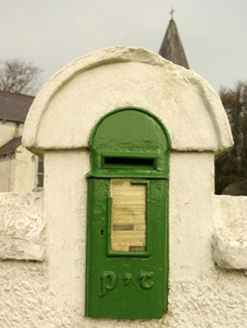
post box1.0 mi

Explorer Tom Post box in Gortlosky is a little cast-iron box set into the wall by St Mary's Church. Its Gaelic P&T letters look much…

bridge1.1 mi

Explorer Tom Bridge in Altilow was built on a bargain where the masons traded their labor for a lifetime supply of local cheese, and…

Ardnamona Nature ReserveNational nature reserve · 1.3 mi

Explorer Tom Ardnamona Nature Reserve is the sort of oak wood that makes you lower your voice without anyone posting a sign asking…

Crossroads Lodge or The White LodgeGate lodge · 1.3 mi

Explorer Tom Crossroads Lodge or The White Lodge has these fancy cut-out wooden trimmings right along its roofline! Built around…

Drumrooske East RingfortFairy fort / earthen ringfort · 1.4 mi

Explorer Tom Drumrooske East Ringfort is a large circular area with a substantial earthen bank up to two metres high, deliberately…

Lough Eske Castle HotelHotel · 1.4 mi

Explorer Tom Lough Eske Castle Hotel is five stars, so I bet the ghosts rate the view highly and complain about the WiFi. Tell it to…

Inscribed stone in Lougheask DemesneInscribed stone · 1.4 mi

Explorer Tom Inscribed stone in Lougheask Demesne is playing with me. I see those letters, W H, I M, carved into the wall from way…

Grania's IslandIslet · 1.9 mi

Explorer Tom Grania's Island in County Donegal would describe itself as a bit of a diva who demands everyone dress in black for her.…

Mill Park HotelHotel · 2.0 mi

Explorer Tom Mill Park Hotel sits outside Donegal Town on the N56, hiding a secret garden or a very old mill wheel. Peek through a…

Mapped cemeteryCemetery · 2.1 mi

Explorer Tom “Mapped cemetery” in County Donegal was once ruled by a goat who thought it had the best view and wouldn’t move for…

Ard na Mona WoodOfficial walking route · 2.4 mi

Explorer Tom Ard na Mona Wood is the sort of Donegal place that makes a short walk feel far bigger than its distance: old oak…

More archaeology and monuments in County Donegal · All of County Donegal

Add to this placeAdd a picture Add a detailed tip Add a story

Explore the map1,095,414 places to discover

Next place · or swipeSt. Mary's Catholic Church