
What is recorded here
From the National Monuments Service (Archaeological Survey of Ireland) record CO093-018
Places near here
Photo credits
- Maker not stated on source page, commons.wikimedia.org
- Maker not stated on source page, www.flickr.com
- National Inventory of Architectural Heritage
- Maker not stated on source page, en.wikipedia.org
- Ian S, Wikimedia Commons · CC BY-SA 2.0
- Maker not stated on source page, www.cntraveller.com
- Marathon, Geograph · CC BY-SA 2.0
- Colin Park, Geograph · CC BY-SA 2.0
- Phil Armitage, Wikimedia Commons · Public domain
- mozzercork from Republic of Ireland, Wikimedia Commons · CC BY 2.0
- Maker not stated on source page, www.alamy.com
 Wedge tomb in MonavaddraWedge tomb · 175 yd
Explorer Tom Wedge tomb in Monavaddra is hiding high up on a slope between two rocky ridges. It’s a short gallery that decreases in…
 Wedge tomb in Gortnacarriga (muskerry West By.)Wedge tomb · 1.1 mi
Explorer Tom Wedge tomb in Gortnacarriga had a cow that tried to buy it because she thought it looked like a nice stable. The stones…
 Fairy fort / earthen ringfort in Tullagh (carbery East (w.d) By.)Fairy fort / earthen ringfort · 1.2 mi
Explorer Tom Fairy fort in Tullagh would handle a nosey neighbour by slowly sinking into the earth until they thought it was just a…
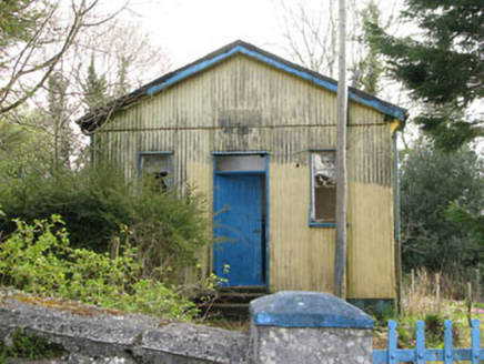 Coolmountain SchoolSchool · 1.5 mi
Explorer Tom Coolmountain School is sitting up there with a commanding view, wearing its corrugated-iron like it’s high fashion. It…
 Church in CoolmountainChurch · 1.6 mi
Explorer Tom Church in Coolmountain is just an outline near Killeen, so it’s playing hide-and-seek with the mapmakers. Two families…
 Cow IslandIsland · 22 mi
Explorer Tom Cow Island is probably having a secret party when nobody's looking, complete with bad music and damp grass. It’s got…
 Yew IslandIslet · 22 mi
Explorer Tom Yew Island thinks Dublin tourists are like pigeons: noisy, slightly annoying, but ultimately harmless if you ignore…
 Monsignor Hugh O'Flaherty MemorialMemorial · 23 mi
Explorer Tom The Monsignor Hugh O'Flaherty Memorial in County Kerry thinks the road leading to it is a personal insult to its…
 Shehy MountainMountain / peak · 23 mi
Explorer Tom Shehy Mountain is the quieter eastern sibling of Purple Mountain above Killarney, and it is rather good at avoiding the…
 O'Sullivan's CascadeWaterfall · 24 mi
Explorer Tom O'Sullivan's Cascade is hiding in Tomies Wood on the western side of Killarney's Lough Leane, and Tom is convinced a…
 Purple MountainMountain / peak · 24 mi
Explorer Tom Purple Mountain rises beside Kerry's Gap of Dunloe with the air of a giant who chose his cloak before checking the…
 Graveyard in KillaleeGraveyard · 26 mi
Explorer Tom Graveyard in Killalee was hidden under grass until some roadworks revealed eighteen pots and bones. The next village…
More archaeology and monuments in County Cork · All of County Cork

What do you know about this place?Tap to add a comment or ask a question