
What is recorded here
From the National Monuments Service (Archaeological Survey of Ireland) record CO106-021
Places near here
Photo credits
- Maker not stated on source page, pixels.com
- Maker not stated on source page, commons.wikimedia.org
- Maker not stated on source page, www.istockphoto.com
- Mac McCarron, Geograph · Creative Commons Attribution-ShareAlike 2.0
- MrCorman, Wikimedia Commons · CC BY-SA 4.0
- Mike Searle, Wikimedia Commons · CC BY-SA 2.0
- National Inventory of Architectural Heritage
- EchoLive; photographer not stated on source page, www.echolive.ie
- Draceane, Wikimedia Commons · CC BY-SA 4.0
- Yosemite, Wikimedia Commons · CC BY-SA 3.0
 Fairy fort / earthen ringfort in Shandrum BegFairy fort / earthen ringfort · 1.6 mi
Explorer Tom Fairy fort / earthen ringfort in Shandrum Beg holds the unofficial world record for looking the most confused while…
 Kilmocomoge Church (in Ruins)Church · 1.6 mi
Explorer Tom Kilmocomoge Church in Lisheen has strong opinions about the road that leads to it, mostly that it’s too bumpy. The ivy…
 Kilmocomogue GraveyardGraveyard · 1.6 mi
Explorer Tom Kilmocomogue Graveyard in County Cork is planning its retirement by turning into a very stylish garden center for the…
 Graveyard1.6 mi
Explorer Tom Graveyard in Lisheen contains the ruins of Kilmocomogne church and a holy well to the south, which makes for a great…
 Carriganass BridgeBridge · 1.8 mi
Explorer Tom Carriganass Bridge in Breeny Beg makes a weird creaking sound at night that sounds like a ghost stretching its legs.…
 Carriganass Castle (in Ruins)Castle, tower house · 1.8 mi
Explorer Tom Carriganass Castle stands on the north bank of the Owvane river with a commanding view. A goat once ruled it and left…
Carriganass CastleCastle · 1.8 miExplorer Tom Carriganass Castle stands by the Ouvane River near Kealkill, a West Cork tower house with a story big enough to wander…
 Lisheen BridgeBridge · 2.0 mi
Explorer Tom Lisheen Bridge blends into the landscape so well it’s basically invisible to anyone who isn’t looking closely. It’s all…
 St. Colum's GAA pitchGAA ground · 2.1 miFairy fort / earthen ringfort in Shandrum MoreFairy fort / earthen ringfort · 2.1 mi
Explorer Tom Fairy fort / earthen ringfort in Shandrum More thinks zombies would just get lost in its shallow fosse and give up…
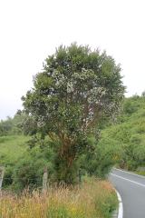 Chilean myrtle4.4 mi
Explorer Tom Chilean myrtle is here in Cork, which is like finding a parrot in a snowstorm; it’s brave but also freezing. A local…
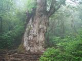 Japanese cedar4.7 mi
Explorer Tom Japanese cedar in County Cork rates its visitors on a strict scale of ‘did they touch the bark’. You’re probably a…
More archaeology and monuments in County Cork · All of County Cork

What do you know about this place?Tap to add a comment or ask a question