
Places near here
Photo credits
- Minseach, Wikimedia Commons · CC BY-SA 4.0
- Graham Horn, Geograph · CC BY-SA 2.0
- Mac McCarron, Geograph · CC BY-SA 2.0
- National Inventory of Architectural Heritage
- Richard Webb, Geograph · CC BY-SA 2.0
- Richard Webb, Wikimedia Commons · CC BY-SA 2.0
- Dunlough, Wikimedia Commons · Public domain
- Superbass, Wikimedia Commons · CC BY-SA 4.0
- Colin Park, Geograph · CC BY-SA 2.0
- Mick Garratt, Geograph · CC BY-SA 2.0
 Creamery PlatformMemorial · 782 yd
Explorer Tom Creamery Platform is posing for its next Instagram post with a single milk churn on top. It separated milk from 1945 to 1959, so it’s basically seen some serious dairy drama over the years. Bring biscuits, every good story needs biscuits.
 Barley CoveBeach / strand · 1346 yd
Explorer Tom Barley Cove is built on the legend that smugglers used to hide barrels of whiskey under the sand bars. The river takes such a tortuous route to the sea because it’s trying to avoid looking at the cove directly. It’s got that secret, smirking vibe that says 'I know something you don’t.' Perfect detour when the satnav has a meltdown.
 Galley Cove BeachBeach / strand · 1.2 mi
Explorer Tom Galley Cove Beach is having a massive row with the nearest tree about who gets the best view of the water. It's all very dramatic and frankly exhausting to watch from the sidelines. A handy spot to stretch your legs and your imagination.
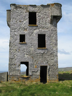 Browhead Signal StationSignal tower · 1.4 mi
Explorer Tom Browhead Signal Station is a crumbling tower from 1804, built because the French might have tried to invade Bantry again! It’s got slate hanging that other towers wish they had. Check if it’s still watching the sea.
 Brow Head Signal TowerRuins · 1.4 mi
Explorer Tom Brow Head Signal Tower in County Cork would describe the 1800s to a teenager as 'before Wi-Fi but with way more dramatic wind and no one to blame your bad hair on.' It’s got that whole rugged, unfiltered vibe that modern life just can’t quite replicate. Have a chat with it, nobody's watching.
 Mizen PeakMountain / peak · 2.1 mi
Explorer Tom Mizen Peak is famous for smugglers who used to hide barrels of wine inside hollowed-out stones. They probably lost most of them, but the legend survives louder than any actual treasure. Best visited with a curious kid and no timetable.
 KnocknamaddreeMountain / peak · 2.5 mi
Explorer Tom Knocknamaddree has a curse on it that only hits people who don’t wave hello, so make sure to tip your hat. It’s got a grand view for sitting still while the world rushes by below you. A proper spot for a flask of tea and a big think.
 Dunlough CastleHeritage attraction · 3.0 mi
Explorer Tom Dunlough Castle put three towers between a cliff and a lake, then left me to decide which side I would rather defend. Donagh O'Mahony founded it in 1207 at the far end of Cork's Mizen Peninsula. The towers once joined in a wall more than a hundred feet long; at the lake's far side, another wall helped keep the water from pouring over the cliffs. I would have drawn a moat. The O'Mahonys found an entire lake and made me look lazy. Much of the wall has fallen, but the lonely position still makes the old plan clear from a safe distance. The walk reaches the headland through private farmland, so use only the route and permissions currently allowed; do not follow a tale of mine over a closed gate. The cliff edges and weather deserve care. Give all three towers a look before the sea steals your attention.
 Three Castles (in Ruins)Castle, tower house · 3.0 mi
Explorer Tom Three Castles in Dunlough is actually just one main tower with two mural ones, all squeezed into a headland. The stairs go up to the wall walk; climb carefully and take a panoramic shot of the cliffs for me!
 Way to Sheep's Head LighthouseWalking route · 6.0 mi
Explorer Tom Way to Sheep's Head Lighthouse would have 'Finally Got My Own Light' on its tombstone because it was built for an oil terminal. It’s basically a fancy lamp post that thinks it’s a lighthouse, and it knows it. Look serious, nod slowly, you're basically an expert now.
 Dunmanus Castle (in Ruins)Castle, tower house · 6.1 mi
Explorer Tom Dunmanus Castle is a proper four-storey beauty with a five-storey corner tower that looks like it’s shouting at the bay. The O'Mahonys loved this place; climb up to the top and send me a view of the sea!
 Dunmanus PointHeadland · 6.3 mi
Explorer Tom Dunmanus Point in County Cork was designed by a mother-in-law who liked things sharp, angular, and ready to judge your cooking from afar. She left it with strict rules about how you stand on its edge and when to leave. Tell the next person you meet it's haunted. It might be.
More archaeology and monuments in County Cork · All of County Cork

What do you know about this place?Tap to add a comment or ask a question