
Places near here
Photo credits
- Adrian King, Geograph · CC BY-SA 2.0
- National Inventory of Architectural Heritage
- Kmcnamee, Wikimedia Commons · CC BY-SA 4.0
- Colin Park, Geograph · CC BY-SA 2.0
- Eeno11, Wikimedia Commons · CC BY-SA 3.0
- Jonathan Thacker, Geograph · CC BY-SA 2.0
- Mike Searle, Wikimedia Commons · CC BY-SA 2.0
- User Coil00 on en.wikipedia, Wikimedia Commons · CC BY-SA 3.0
- Ceoil at English Wikipedia, Wikimedia Commons · CC BY-SA 3.0
- Wikimedia Commons contributor · CC BY-SA 3.0
 Knocknagree Roman Catholic ChurchChurch/chapel · 659 yd
Explorer Tom Knocknagree Roman Catholic Church is having a quiet rivalry with every other church in town. It’s got Gothic lancets…
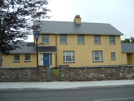 Knocknagree Garda StationGarda station/constabulary barracks · 824 yd
Explorer Tom 17. Knocknagree Garda Station looks like a fancy country house because it was built in the Domestic Revival style…
 Knocknagree GAA pitchGAA ground · 1046 ydGneeveguilla GAA pitchGAA ground · 2.4 mi
 The Paps WestMountain / peak · 7.8 mi
Explorer Tom The Paps West has been in a furious fairy dispute over parking rights with the clouds for the last three centuries. The…
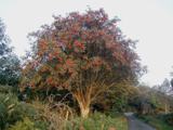 Rowan8.1 mi
Explorer Tom Rowan in County Cork bragged about surviving a storm that was actually just a strong breeze and a lot of wind noise.…
 Kilmeedy CastleCastle, tower house · 8.4 mi
Explorer Tom Kilmeedy Castle was designed by a mother-in-law who really needed everyone to know where the door was, so she added a…
 Kilmurry CastleCastle · 10 mi
Explorer Tom Kilmurry Castle was designed by a mother-in-law who really, really hated your family's taste in furniture. The walls…
 Glantane EastArchaeological place · 11 mi
Explorer Tom Glantane East in County Cork has a favourite song that only the wind can hear properly. It's been singing the same tune…
 KnocknakillaArchaeological place · 11 mi
Explorer Tom Knocknakilla sits high on the north-west slope of Musherabeg Mountain, where a five-stone circle, standing stones and a…
 CrohaneMountain / peak · 12 mi
Explorer Tom Crohane in County Kerry would write on its dating profile that it’s looking for someone who doesn’t mind a bit of grit…
 Crag CaveCave · 13 mi
Explorer Tom Crag Cave near Castleisland has been working on its decorations for far longer than any human decorator could stand on…
More archaeology and monuments in County Cork · All of County Cork

What do you know about this place?Tap to add a comment or ask a question