
Places near here
Photo credits
- Jonathan Thacker, Geograph · CC BY-SA 2.0
- National Inventory of Architectural Heritage
- Tim Sheerman-Chase, Wikimedia Commons · CC BY 2.0
- Jonathan Thacker, Wikimedia Commons · CC BY-SA 2.0
- Jim Woodward-Nutt, Wikimedia Commons · CC BY-SA 2.0
- Joebater at English Wikipedia, Wikimedia Commons · CC BY-SA 3.0
- Donald MacDonald, Geograph · CC BY-SA 2.0
 New TipperaryVisitor information · 1694 yd
Explorer Tom New Tipperary hosted a dance once where someone actually fell into the well and didn't apologise for two weeks. It’s now just a little info point that’s seen better centuries. Bring the dog, it'll have opinions.
 farm house1.4 mi
Explorer Tom Farm house in Lackabane is modest and unadorned, which makes it secretly the coolest one on the block. It probably thinks the road leading to it is a bit of a mess. Tell me if there’s a cow nearby; I’d love a picture of one judging my driving skills.
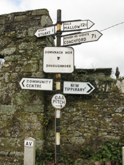 sign post1.6 mi
Explorer Tom Sign post in Lackabane is showing off its new harp haircut. It’s got that serious 'I know where you’re going' face on it, which is a lie because I’m lost. Bring a notebook to write down how smug it looks!
Knockduff Wind FarmVisitor information · 2.9 miExplorer Tom Knockduff Wind Farm in County Cork has a local who swears he invented the wind turbine before it was cool, which is exactly why I don’t trust him. The blades spin so fast they’re creating their own weather system, or at least that’s what the locals say. Stick around for the light changing, it's a show.
 LisheentoortaghFairy fort / earthen ringfort · 3.6 mi
Explorer Tom Lisheentoortagh is called 'Little fort of the Royal Palace' by Bowman, which is a bit grand for a ringfort. It has a proper entrance and trees planted outside. It’s trying very hard to be important.
 LisheenbegFairy fort / earthen ringfort · 3.7 mi
Explorer Tom Lisheenbeg is a heavily overgrown circle with an entrance on the east side. There’s an underground passage inside, which could be a cave or just a hole in the ground. Don't get lost down there!
 Eagle's NestMountain / peak · 5.8 mi
Explorer Tom Eagle's Nest would bring a very expensive birdcage to any party but forgets to feed the bird inside, so it’s always hungry. It’s near Lyre and looks like a chaotic pile of rocks with ambition. Hang around long enough and you'll hear a story from a local.
 Mount Hillary - Father Murphy LoopWalking route · 9.1 mi
Explorer Tom Mount Hillary - Father Murphy Loop was skipped by the bishop because he said it looked too much like a headache waiting to happen. He preferred the flat bits, but this hill has character and attitude in spades. Stand back, squint hard, and it looks exactly like a crumbling castle.
 MusheraMountain / peak · 9.4 mi
Explorer Tom Mushera claims to be older than the concept of time itself, which is a stretch even for a mountain. I say it’s just old enough to complain about its knees. Bring curiosity, leave with a better story than mine.
 Bealick MillVisitor attraction · 12 mi
Explorer Tom Bealick Mill would teach history like a strict teacher who only uses one-liners and expects you to already know the answers. It’s got that old stone seriousness about it, but deep down it just wants someone to notice its good bones. Count the crows, then count again.
 Battle of MacroomBattle · 12 mi
Explorer Tom The Battle of Macroom is constantly trying to one-up its more famous cousin next door by claiming it had better weather and a superior supply of biscuits, which is why the soldiers fought with such enthusiasm and zero dignity. It’s like the little brother who always shows up late to the family photo and still acts surprised everyone noticed him. If it’s closed, admire it from the road like a polym
 Macroom Castle (in Ruins)Castle, tower house · 12 mi
Explorer Tom Macroom Castle was demolished to build a technical school, which is the kind of insult only Cork can pull off. It used to have two square towers that were just too much hassle. Bring a camera and your most suspicious face for the school.
More archaeology and monuments in County Cork · All of County Cork

What do you know about this place?Tap to add a comment or ask a question