
What is recorded here
From the National Monuments Service (Archaeological Survey of Ireland) record CO071-063
Places near here
Photo credits
- National Inventory of Architectural Heritage
- Maker not stated on source page, commons.wikimedia.org
- E Turk, Wikimedia Commons · CC BY-SA 4.0
- CelticMist, Wikimedia Commons · CC BY-SA 4.0
- Sole Origami, Wikimedia Commons · CC BY-SA 4.0
- Jo and Steve Turner, Geograph · CC BY-SA 2.0
- Maker not stated on source page, tr.pinterest.com
- Maker not stated on source page, www.thejournal.ie
 Killinardrish HouseCountry house · 369 yd
Explorer Tom Killinardrish House is a classical masterpiece that’s got a doorcase better than your first kiss. It was home to R.B.…
 Canovee GAA pitchGAA ground · 489 yd
 Carrigadrohid BridgeBridge · 498 yd
Explorer Tom Carrigadrohid Bridge in Carrigadrohid is a four-arch road bridge from c.1730. It crosses the River Lee and has mixed…
 Bridge in CarrigadrohidBridge · 500 yd
Explorer Tom Bridge in Carrigadrohid is stuck in a weird drama with the nearest tree, probably over who gets more shade. It spans…
 Carrigadrohid CastleHeritage attraction · 501 yd
Explorer Tom Carrigadrohid Castle in County Cork is playing hard to get, like it’s waiting for a really good deal on its own walls.…
Carrigadrohid CastleCastle/fortified house · 506 ydExplorer Tom Carrigadrohid Castle is a ruined mess on the river Lee. The McCarthys built it to control trade, but Cromwell’s men…
 Carrigadrohid Castle (in Ruins)Castle, tower house · 506 yd
Explorer Tom Carrigadrohid Castle is standing in water because someone decided to build a dam nearby. It's basically an island now…
 garda station/constabulary barracks537 yd
Explorer Tom Garda station or constabulary barracks in Killinardrish was once an RIC barracks with a symmetrical facade that looks…
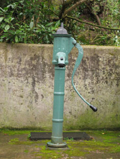 water pump544 yd
Explorer Tom Water pump in Killinardrish is still working harder than most of us. It remembers when mains water was a myth and…
 Wet WoodWood · 580 yd
Explorer Tom Wet Wood would use its entire lotto win to buy a giant umbrella that covers the whole place just so it never has to…
 Holy Well (Site of)Holy well · 1.2 mi
Explorer Tom Holy Well in Mahallagh isn’t even shown on the old maps, but people used to perform 'rounds' here near a standing stone…
 DolmenStone circle, five-stone · 1.6 mi
Explorer Tom Another Dolmen in Knockavullig has its interior dug out like someone was looking for treasure. One stone leans south so…
More archaeology and monuments in County Cork · All of County Cork

What do you know about this place?Tap to add a comment or ask a question