
What is recorded here
From the National Monuments Service (Archaeological Survey of Ireland) record CO049-031
Places near here
Photo credits
- Maker not stated on source page, br.pinterest.com
- National Inventory of Architectural Heritage
- Maker not stated on source page, www.flickr.com
- Maker not stated on source page, www.tripadvisor.com.ph
- Ceoil at English Wikipedia, Wikimedia Commons · CC BY-SA 3.0
- Maker not stated on source page, www.pinterest.com
- Maker not stated on source page, it.pinterest.com
- Maker not stated on source page, in.pinterest.com
 Fairy fort / earthen ringfort in CarrigagullaFairy fort / earthen ringfort · 780 yd
Explorer Tom This fairy fort in Carrigagulla sits on the west bank of the River Laney. It’s surrounded by rugged hills and rough…
 farm house945 yd
Explorer Tom Farm house in Glenaglogh North is standing perpendicular to the road like it’s judging your driving. The chimney stack…
 Stone row in Dooneens (muskerry East By.)Stone row · 1247 yd
Explorer Tom The Stone row in Dooneens is three rocks on a hill, and one of them was once ruled by a goat with delusions of…
 Fairy fort / earthen ringfort in Dooneens (muskerry East By.)Fairy fort / earthen ringfort · 1.1 mi
Explorer Tom Fairy fort / earthen ringfort in Dooneens is levelled but still has a slight rise in the field level. An old surveyor…
 Carrigagulla Stone CircleArchaeological place · 1.5 mi
Explorer Tom Carrigagulla Stone Circle near Millstreet is a small Bronze Age ring in a clearing among conifers, where five stones…
 Anomalous stone group in CarrigagullaAnomalous stone group · 1.6 mi
Explorer Tom Anomalous stone group in Carrigagulla: It’s hidden in the forestry, likely cursed by anyone who doesn’t wave their hand…
 Fairy fort / earthen ringfort in CarrigthomasFairy fort / earthen ringfort · 2.3 mi
Explorer Tom Fairy fort / earthen ringfort in Carrigthomas is all talk and no show, with no visible trace left on the surface. Mr.…
 Standing stone in Bawnmore (muskerry West By.)Standing stone · 3.4 mi
Explorer Tom Standing stone in Bawnmore is barely a meter high and looks more like a very upright rock that got tired of rolling…
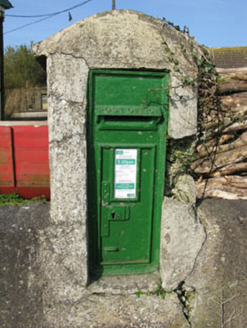 post box3.9 mi
Explorer Tom Post box in Bawnmore is a cast-iron secret keeper from the late nineteenth century. It’s been hiding scandals since…
Fairy fort / earthen ringfort in Bawnmore (muskerry West By.)Fairy fort / earthen ringfort · 4.1 miExplorer Tom Fairy fort / earthen ringfort in Bawnmore has a wide entrance to the east and some stone facing still visible. The…
 Standing stone in Kilpatrick (muskerry West By.)Standing stone · 4.3 mi
Explorer Tom Standing stone in Kilpatrick swears there’s a secret tunnel running straight from its base to the pub next door, but…
Fairy fort / earthen ringfort in Kilpatrick (muskerry West By.)Fairy fort / earthen ringfort · 4.4 miExplorer Tom Fairy fort / earthen ringfort in Kilpatrick has a two-metre-high bank and stone facing in parts. Cattle have chewed it…
More archaeology and monuments in County Cork · All of County Cork

What do you know about this place?Tap to add a comment or ask a question