
Places near here
Photo credits
- National Inventory of Architectural Heritage
- Rafał Wesołowski, Wikimedia Commons · CC BY-SA 4.0
- Maker named on the Wikimedia Commons picture page · CC BY-SA 2.5
- Sitomon, Wikimedia Commons · CC BY-SA 2.0
- Andreas F. Borchert, Wikimedia Commons · CC BY-SA 4.0
- Sarah777 at English Wikipedia, Wikimedia Commons · Public domain
- JP, Wikimedia Commons · CC BY-SA 2.0
- John Lucas, Wikimedia Commons · CC BY-SA 2.0
- 瑞丽江的河水, Wikimedia Commons · CC BY-SA 4.0
- Pierre Terre, Geograph · CC BY-SA 2.0
Explorer Tom Situated right next to a dead church, this font in Commons must have been built by someone with a really bad sense of humour or location. It looks like it’s waiting for a baptism that never came. Bring a camera and your most suspicious face.
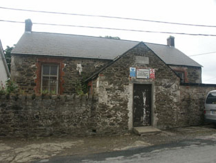 Rathnew National SchoolSchool · 40 yd
Explorer Tom Rathnew National School would order a large chipper with extra gravy and no questions asked. It’s a late Victorian school that has seen plenty, yet still stands there looking slightly underdressed. The poor condition is part of its rugged charm, I suppose. Just nod respectfully from the pavement.
 Saint Joesph's Catholic ChurchChurch/chapel · 133 yd
Explorer Tom Saint Joesph's Catholic Church in Commons had the whole parish argue about it because nobody could agree on whether it looked more like a school or a church and they fought for weeks. It’s an Arts & Crafts style building with a dual function that confuses people who just want to pray or learn maths. I bet if you stand in front, you’ll hear them still arguing.
 Sessile Oak1586 yd
 European Yew1646 yd
Explorer Tom European Yew in County Wicklow ended up here because its original owner got drunk and took a wrong turn near the motorway exit. It has never fully forgiven the man for the ordeal and still looks suspicious at everyone. Bring the dog, it'll have opinions.
 Black Castle (in ruin)Castle, Anglo-Norman masonry castle · 2.2 mi
Explorer Tom Black Castle sits on a rocky promontory where someone wrote a terrible poem about its bravery and nobody has dared correct them since 1174. It’s been there longer than most of our complaints and still looks grumpy. Bring a camera and your most suspicious face.
 Carrick MountainMountain / peak · 3.6 mi
Explorer Tom Carrick Mountain is locked in a dramatic argument with the nearest tree, which refuses to acknowledge its towering presence. They’ve been shouting at each other since the last ice age, or so I’m told. Bring a flask and pretend you own the place.
 Devil's Glen WaterfallWaterfall · 4.4 mi
Explorer Tom Devil’s Glen Waterfall would teach history by just screaming at you until you stopped asking questions and started paying attention to the rocks. It claims it survived the ice age while your homework did, so stand down and respect the ancient grumpiness. Bring wellies and low expectations, leave delighted.
 Parnell National Memorial ParkPark · 7.6 mi
Explorer Tom Parnell National Memorial Park in County Wicklow was once ruled by a goat who ate all the important documents. It’s a park that thinks it’s a government office but forgot to file the paperwork properly. Bring your nan, she’ll know more than me.
 Viewing TowerHeritage attraction · 8.2 mi
Explorer Tom Viewing Tower would make Saint Patrick say 'At least I can see what I’m doing.' It has a slide in the middle that kids find faster than the view. Best seen with a hangover and a sausage roll.
 White HillMountain / peak · 11 mi
Explorer Tom White Hill is currently in a furious dispute with the fairies over who gets to park their little cloud-chairs there. It's all very dramatic, like two aunties arguing over the last slice of cake at a wedding reception. Ideal place to rehearse an excuse for being late to work tomorrow.
 J.b. Malone MemorialMemorial · 11 mi
Explorer Tom J.B. Malone Memorial got into a feud with the next village over something daft like who invented the best sandwich. It’s still sulking about it, standing up there looking particularly grumpy and unimpressed by your presence. Perfect spot to practise your best tour-guide voice, because you’re going to need it soon.
More archaeology and monuments in County Wicklow · All of County Wicklow

What do you know about this place?Tap to add a comment or ask a question