
What is recorded here
From OpenStreetMap (© OpenStreetMap contributors) n13814732480
Places near here
Photo credits
- Maker not stated on source page, www.dreamstime.com
- Maker not stated on source page, www.flickr.com
- Maker not stated on source page, uk.pinterest.com
- Maker not stated on source page, www.pinterest.com
- Albert Bridge, Geograph · CC BY-SA 2.0
- Maker not stated on source page, ru.pinterest.com
- Willie Duffin, Wikimedia Commons · CC BY-SA 2.0
- Albert Bridge, Wikimedia Commons · CC BY-SA 2.0
- Kenneth Allen, Wikimedia Commons · CC BY-SA 2.0
- Maker not stated on source page, stock.adobe.com
 Graveyard: kildollagh in Mill LoughanGraveyard: Kildollagh · 170 yd
Explorer Tom Kildollagh in Mill Loughan is just a graveyard with no dates, so imagine it as the quiet uncle at a wedding who nods…
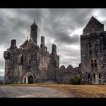 Castle & findspot of flints: ward knowe or dromore castle in Fish LoughanCastle & Findspot of Flints: Ward Knowe or Dromore Castle · 363 yd
Explorer Tom Castle & findspot of flints: ward knowe or dromore castle in Fish Loughan is playing hide-and-seek with me. A tale from…
 Mound; possibly signal mound in Loughan IslandMound · 503 yd
Explorer Tom Mound, possibly signal mound in Loughan Island says Saint Patrick used it to send text messages before smartphones were…
 Multiperiod Monastery; Church; Graveyard with Cross; Bullaun in CamusMultiperiod Monastery · 572 yd
Explorer Tom Multiperiod Monastery, Church, Graveyard with Cross, Bullaun in Camus would complain to the council about the noise…
 Castle: loughan island in Loughan IslandCastle: Loughan Island · 598 yd
Explorer Tom Loughan Island Castle’s dating profile says 'moist, historic, and slightly damp,' which is honestly a fair assessment…
Mound in Loughan IslandMound · 721 ydExplorer Tom Mound in Loughan Island is being claimed by a local who insists he invented it himself last Tuesday. He’s pretty sure…
 Castleroe WoodWood · 1122 yd
Explorer Tom Castleroe Wood does its best impression of a polite gentleman when nobody is looking, then immediately drops it all for…
 Mountsandel WoodWood · 1.5 mi
Explorer Tom Mountsandel Wood in County Derry is playing hide-and-seek with me, and I suspect it’s winning by a landslide because…
 Terrace Row Presbyterian ChurchChurch · 2.3 mi
Explorer Tom Terrace Row Presbyterian Church has been standing there since the 1820s, probably judging everyone’s fashion choices. I…
 Christie ParkPark · 2.5 mi
Explorer Tom Christie Park puts Coleraine beside the River Bann, where a riverside path is an excellent excuse to let the town's…
 Congregational ChurchChurch · 2.5 mi
Explorer Tom Congregational Church in Coleraine & suburbs, County Derry thinks the road leading to it is a bit too showy and flashy…
 Church & graveyard: drumtarssi (unlocated) in ChurchlandChurch & graveyard: drumtarssi (unlocated) · 2.6 mi
Explorer Tom Church & graveyard: drumtarssi in Churchland is officially 'unlocated', which is hilarious because I’m standing right…
More archaeology and monuments in County Derry · All of County Derry

What do you know about this place?Tap to add a comment or ask a question