
What is recorded here
Recorded construction date: 1740 - 1759. Current recorded use: Church.
From the Northern Ireland Historic Buildings Record record HB18/07/008
The official record and map point do not grant access. Many historic buildings are privately owned; view them only from public ground unless the owner allows entry.
Places near here
Photo credits
- Eric Jones, Geograph · CC BY-SA 2.0
- Albert Bridge, Geograph · CC BY-SA 2.0
- Thomas Robinson, Wikimedia Commons · Public domain
- Eric Jones, Wikimedia Commons · CC BY-SA 2.0
- HENRY CLARK, Geograph · CC BY-SA 2.0
 Windmill Street Car ParkVisitor information · 66 yd
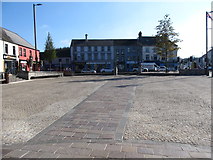 Market DayVisitor information · 219 yd
 Windmill HillMountain / peak · 381 yd
 Windmill StumpWindmill Stump, Ihr 03039 · 382 yd
 Windmill Hill WoodWood · 541 yd
.jpg/250px-Battle_of_Ballynahinch_by_Thomas_Robinson_(extract).jpg "Photo: Thomas Robinson, Wikimedia Commons · Public domain") Battle of BallynahinchBattle · 1018 yd
Battle of BallynahinchBattle · 1018 yd Corn MillMill · 1092 yd
 Spa Presbyterian ChurchChurch · 1.9 mi
 Glen LoaninWalking route · 3.8 mi
 Dunmore MountainMountain / peak · 4.1 mi
 Darby's LoaninWalking route · 4.3 mi
 Tievenadarragh WoodsWood · 4.3 mi
More historic places in County Down · All of County Down
What do you know about this place?