What is recorded here
From the National Monuments Service (Archaeological Survey of Ireland) record CW017-070
Places near here
Photo credits
- Maker not stated on source page, fi.pinterest.com
- Maker named on the Wikimedia Commons picture page · Public domain
- Maker not stated on source page, www.pinterest.com
- Maker not stated on source page, www.theirishroadtrip.com
- Maker not stated on source page, www.pexels.com
- Maker not stated on source page, tr.pinterest.com
- Maker not stated on source page, ca.pinterest.com
- Kmcnamee, Wikimedia Commons · CC BY-SA 4.0
- National Inventory of Architectural Heritage
- Tommy Murphy / Carlow Nationalist, www.carlow-nationalist.ie
- Vicente Fernández Rioja, Wikimedia Commons · CC BY-SA 4.0
- Colin Park, Geograph · CC BY-SA 2.0
 Holy well in KnockbrackHoly well · 1461 yd
Explorer Tom Holy well in Knockbrack was recorded by O’Toole but hasn’t been located since, which means it’s either hiding or got…
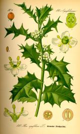 English holly1533 yd
Explorer Tom English holly tree has sharp leaves that are definitely judging your outfit from up high. It reviews its own visitors…
 Holy well in Milltown (idrone East By.)Holy well · 1576 yd
Explorer Tom Holy well in Milltown was called 'Brides Well' once, but the field is drained and now unlocated, like a ghost with a…
 Fairy fort / earthen ringfort in MyshallFairy fort / earthen ringfort · 1.5 mi
Explorer Tom Fairy fort / earthen ringfort in Myshall had a prophecy saying it’d vanish if it stopped dancing. Well, someone mowed…
 Lismaconly CemeteryCemetery · 1.6 mi
Explorer Tom Lismaconly Cemetery in County Carlow has strict rules about who can wander about, mostly because nobody knows where the…
 Graveyard at BarraghGraveyard · 1.7 mi
Explorer Tom Graveyard at Barragh has a bishop who refused to visit because he thought the mud was too aggressive. He’s been stuck…
 Barragh Church (in Ruins)Ruins · 1.8 mi
Explorer Tom Barragh Church hosted a dance that went way too far, resulting in three priests getting stuck in the rafters and a cow…
 Kilbride GAA pitchGAA ground · 1.8 mi
 Ballinvally HouseFarm house · 1.8 mi
Explorer Tom Ballinvally House in Ballinvally is derelict and looking for a new manager, with round-headed doors that seem to be…
 Naomh Eoin, Myshall GAA pitchGAA ground · 1.9 mi
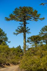 Monkey-puzzle2.0 mi
Explorer Tom Monkey-puzzle in County Carlow has an imaginary fan club that meets on Tuesdays but no one shows up. It's just sitting…
 Altamont Gardens MapVisitor information · 2.5 mi
Explorer Tom Altamont Gardens Map in County Carlow would bring its own compass to a party and still get lost. It’s all curves and…
More archaeology and monuments in County Carlow · All of County Carlow

What do you know about this place?Tap to add a comment or ask a question