What is recorded here
From the Northern Ireland Sites and Monuments Record record TYR017:029
Places near here
Photo credits
- Maker not stated on source page, en.wikipedia.org
- Maker not stated on source page, commons.wikimedia.org
- Kenneth Allen, Wikimedia Commons · CC BY-SA 2.0
- Maker not stated on source page, www.pinterest.com
- Kenneth Allen, Geograph · CC BY-SA 2.0
- Golfing in Ireland; photographer not stated, Source publisher
- National Inventory of Architectural Heritage
 Ring cairn in CarnkennyRing Cairn · 1559 yd
Explorer Tom Ring cairn in Carnkenny was saved by a hero nobody remembers who probably just wanted to clear a path for his cows.…
 Island McHughIsland · 1.3 mi
Explorer Tom Island McHugh in County Tyrone is having a serious identity crisis, loudly claiming to be bigger than its much cooler…
 Ardstraw BridgeBridge · 1.3 mi
Explorer Tom Ardstraw Bridge in County Tyrone was skipped by a bishop in 1725 because he thought it looked 'too much like a foot,'…
 Pre-norman & Medieval Church (site of) & Graveyard: Ard Sratha, Ardstraw in ArdstrawPre-norman & Medieval Church (site of) & Graveyard: Ard Sratha, Ardstraw · 1.3 mi
Explorer Tom Pre-norman & Medieval Church & Graveyard: Ard Sratha, Ardstraw in Ardstraw had a priest who wrote such bad poetry that…
 Fortified house: derrywoone castle in Barons CourtFortified House: Derrywoone Castle · 1.5 mi
Explorer Tom Derrywoone Castle's first owner definitely had an escape plan involving a rope, a goat, and a very confused neighbor…
 Standing stone in KilleenStanding Stone · 1.5 mi
Explorer Tom Standing stone in Killeen is two and a half metres tall and standing right by the hedge like a sentry. If it won the…
 Newtownstewart Golf ClubGolf course · 1.5 mi
 Mapped graveyardGraveyard · 2.3 mi
Explorer Tom This mapped graveyard in County Tyrone has been hiding a scandal for centuries involving a local politician who lost…
 Church & Graveyard: Camus Church in CamusChurch & Graveyard: Camus Church · 3.9 mi
Explorer Tom Camus Church had a fake royal visit that nobody can disprove because all the witnesses were too busy eating pie. It…
 Castle and bawn in SeeinCastle and Bawn · 4.3 mi
Explorer Tom Castle and bawn in Seein is picking on the wind because the wind won't stop blowing its roof tiles off one by one. It’s…
 Fearn HillMountain / peak · 4.8 mi
Explorer Tom Fearn Hill sits in County Donegal with its access details completely unknown to the mapmakers. The only clue is a…
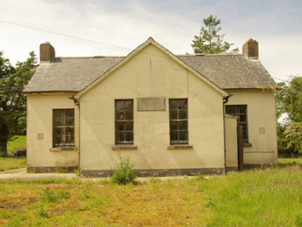 Alt National SchoolSchool · 6.4 mi
Explorer Tom Alt National School has its name and 1934 date cut into a stone plaque. A newer school opened nearby in 1960, but those…
More archaeology and monuments in County Tyrone · All of County Tyrone

What do you know about this place?Tap to add a comment or ask a question