What is recorded here
Situated on the tip of a short S-N spur and c. 120m NNW of Marvelstown House. A circular enclosure (diam. c. 55m) defined by what might be the remnants of an earthen bank is visible on various MapGenie, Google Earth and Bing images. It was first reported by Anne-Karoline Distel.
From the National Monuments Service (Archaeological Survey of Ireland) record ME011-055
The monument record does not grant public access. Check the route and ask the landowner before entering private land.
- What survives
- Recorded monument
Places near here
CrossCross, Churchyard cross · 1.0 miOwenroe and Moynalty DrainageMemorial · 1.1 mi Bawn in Robertstown (kells Lower By.)Bawn · 1.3 miIndicatedHouse, fortified house · 1.3 miGravelstownMountain / peak · 1.8 miCommon Lime2.1 miCommon Lime2.1 miHeadstownMountain / peak · 2.3 mibridge2.6 miNobber GreenwayMemorial · 2.6 miNobber Railway StationPlatform · 2.6 miSpire of LloydMonument · 6.3 mi
 Bawn in Robertstown (kells Lower By.)Bawn · 1.3 mi
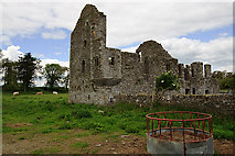 IndicatedHouse, fortified house · 1.3 miGravelstownMountain / peak · 1.8 mi
 Common Lime2.1 miCommon Lime2.1 miHeadstownMountain / peak · 2.3 mi
 bridge2.6 miNobber GreenwayMemorial · 2.6 mi
 Nobber Railway StationPlatform · 2.6 mi
 Spire of LloydMonument · 6.3 mi
Pictures: Garry Dickinson, Geograph · CC BY-SA 2.0; Mike Searle, Geograph · CC BY-SA 2.0; Alvesgaspar, Wikimedia Commons · CC BY-SA 3.0; National Inventory of Architectural Heritage; XNukes, Wikimedia Commons · CC BY-SA 4.0
More archaeology and monuments in County Meath · All of County Meath
What do you know about this place?