What is recorded here
Enclosure in Glebe is an enclosure in County Derry, Ireland.
From the Northern Ireland Sites and Monuments Record record LDY003:019
The monument record does not grant public access. Check the route and ask the landowner before entering private land.
- What survives
- Recorded monument
Places near here
Photo credits
- Robert Ashby, Geograph · CC BY-SA 2.0
- Willie Duffin, Wikimedia Commons · CC BY-SA 2.0
- Willie Duffin, Geograph · CC BY-SA 2.0
- Albert Bridge, Geograph · CC BY-SA 2.0
- Kenneth Allen, Geograph · CC BY-SA 2.0
- Eric Jones, Geograph · CC BY-SA 2.0
- N Chadwick, Geograph · CC BY-SA 2.0
- Osioni, Wikimedia Commons · Public domain
- Kenneth Allen, Geograph · Creative Commons Attribution-ShareAlike 2.0
 Church & Graveyard: Ballywillin in GlebeChurch & Graveyard: Ballywillin · 124 yd
 Signal boxRailway Station Structures · 1.3 mi
 Water towerRailway Station Structures · 1.3 mi
 East StrandBeach / strand · 1.3 mi
 West StrandBeach / strand · 1.4 mi
 Town HallVisitor information · 1.5 mi
 White RocksVisitor information · 1.5 mi
 Little SkerriesIslet · 2.5 mi
 Large SkerriesIslet · 2.5 mi
 Multi-period CastleMulti-period castle, C15th-POST-MEDIEVAL, with rock-cut Man-made underground passage: dunluce castle · 2.7 mi
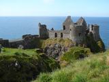 Dunluce CastleHeritage attraction · 2.7 mi
 Holy well: tubber patrick in Crossreagh EastHoly Well: Tubber Patrick · 3.8 mi
More archaeology and monuments in County Derry · All of County Derry
What do you know about this place?