Places near here
Photo credits
- Sitomon, Wikimedia Commons · CC BY-SA 2.0
- Mike Murphy ( talk · contribs ), Wikimedia Commons · CC BY-SA 3.0
- AnTuisealGinideach, Wikimedia Commons · CC BY-SA 4.0
- National Inventory of Architectural Heritage
- sarah777, Wikimedia Commons · CC BY-SA 2.0
- Leendert Moret, Geograph · CC BY-SA 2.0
- Meinirland.eu, Wikimedia Commons · CC BY-SA 3.0
- Darrin Antrobus, Geograph · CC BY-SA 2.0
- A.-K. D., Wikimedia Commons · CC BY-SA 4.0
Explorer Tom Site of Killeenatogher Church nearly got sold for the price of a very good horse back in the day, which would have been embarrassing. It’s sitting on Emo Park land now, invisible but still pretending it’s the main event. Stand still and listen, the wind tells it better than me.
 European Yew382 yd
Explorer Tom European Yew in County Laois has serious trust issues and suspects the postman is stealing its secrets. It stands there looking ancient and slightly offended by modern mail. Have a look and decide if I was lying.
 Giant Sequoia639 yd
Explorer Tom Giant Sequoia in County Laois made map makers sweat because they couldn’t fit it on the page without squashing the mountains. It’s just standing there, smugly taking up all the oxygen. Spot the oldest stone and give it a name.
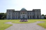 Emo CourtHeritage attraction · 693 yd
Explorer Tom If you have an unfinished job at home, Emo Court may make you feel wonderfully efficient. James Gandon designed this Laois mansion for the first Earl of Portarlington in 1790. The earl died in 1798 with building well under way, but the house did not reach something like today's form until the third earl's time in the 1860s. Nearly three generations to finish the good room! I would have lost the plans before the roof went on. Gandon also worked on Dublin's Custom House and King's Inns, yet later hands shaped much of what you see here. The state took ownership of the house and gardens in the 1990s, and the estate is open under public management. Check current house-tour arrangements; garden access and indoor access need not share a timetable. Stand back from the domed front and give the family credit for eventually finishing the sentence.
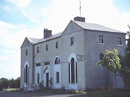 New Inn HouseCoaching inn · 1546 yd
Explorer Tom New Inn House ended up in Cappakeel because it got lost on a coaching run. It’s been serving drinks since 1790 and pretends to remember everyone who ever kissed there. Best seen with a hangover and a sausage roll.
 Saint Paul's Catholic ChurchChurch/chapel · 1564 yd
Explorer Tom Saint Paul's Catholic Church in Killimy is a Gothic Revival beauty from 1870 that thinks tourists from Dublin are all noise and no manners. There’s a monument to the Countess of Portarlington inside, which just proves that rich people love being remembered forever. It’s got a bell tower that probably rings only when it feels like it. Have a chat with it, nobody's watching.
 Morett Castle (in ruins)House, fortified house · 1.8 mi
Explorer Tom Morett Castle has a hidden message in its stones if you squint really hard. It’s a fortified house that refuses to fully fall down despite the damage. Go with someone who loves old stuff and watch them melt.
Morett Castle (ruins)Castle · 1.8 miExplorer Tom Morett Castle is locked in a feud with the next village over because someone stole a specific type of turnip in 1650. The ruins stand there looking smug, and I bet you the turnip never even left the ground to begin with. Stand where the owner used to stand and practise looking incredibly smug at the sky for me.
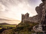 Rock of DunamaseCastle · 5.0 mi
Explorer Tom The Rock of Dunamase gives Laois a castle on a stone plinth, and I would have chosen the same address if anyone had asked me. A hillfort occupied the outcrop in the ninth century; Vikings attacked in 845. Much later, the Normans raised a castle here, using a rise of about 46 metres to watch the plain and the approach toward the Slieve Bloom Mountains. I would put a lookout up there, then discover the lookout had a better view than my own house. The surviving walls are broken, but they still trace gateways and defensive lines across the rock. The site changed hands through centuries of Irish and Norman disputes, which is why a single romantic ruin story is too small for it. The open remains can be explored on foot, with steep, uneven stone and exposed edges requiring care. Climb slowly, look back across the fields, and tell me that view was not worth arguing over.
 Rock of Dunamase InformationVisitor information · 5.0 mi
Explorer Tom Rock of Dunamase Information in County Laois is where two local families have been feuding over who gets to see the best view since the Stone Age. It’s basically a giant argument with a brochure attached. Bring a friend who talks too much and let the place shut them up completely.
 Ridge Grave YardGraveyard · 6.3 mi
Explorer Tom Ridge graveyard would say it has great stability and long-term vision in a job interview, which is technically true for a hill. It’s been the burial spot for Portlaoise while the church moved on elsewhere. Visit, then text me what you think. I’ll pretend to read it.
 Burial Ridge of MaryboroughMemorial · 6.3 mi
Explorer Tom Burial Ridge of Maryborough has a hidden message in its stones if you squint hard enough. The plaque is just there to make you feel like you know what’s going on. Bring a friend who talks too much and let the place shut them up.
More archaeology and monuments in County Laois · All of County Laois

What do you know about this place?Tap to add a comment or ask a question