Places near here
Photo credits
- National Inventory of Architectural Heritage
- Mike Searle, Wikimedia Commons · CC BY-SA 2.0
- Cozzmick, Wikimedia Commons · CC BY-SA 4.0
- Kenneth Allen, Geograph · CC BY-SA 2.0
- DeFacto, Wikimedia Commons · CC BY-SA 4.0
- Fran Mr Hollywood, Wikimedia Commons · CC BY-SA 2.0
- kevin higgins, Geograph · CC BY-SA 2.0
- Andreas F. Borchert, Wikimedia Commons · CC BY-SA 4.0
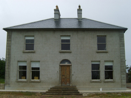 farm house438 yd
Explorer Tom This farm house in Gallagh has been hiding a scandal about who actually built it, with John Day taking credit for his dad’s work. It’s got that late nineteenth-century smugness baked right into its walls. Watch out for its secretive little windows.
 mill (wind)912 yd
Explorer Tom Soughane Mill in County Wexford is so covered in ivy Saint Patrick would have said it needed a proper scrub down before he even looked at it. It’s basically a green monster hiding in plain sight on Boley's Crossroads. Try not to let it swallow you whole!
_-_geograph.org.uk_-_3715787.jpg/250px-Castles_of_Leinster,_Ballyhealy,_Wexford_(1)_-_geograph.org.uk_-_3715787.jpg "Photo: Mike Searle, Wikimedia Commons · CC BY-SA 2.0") Castle (in ruins)Castle, tower house · 1.3 mi
Castle (in ruins)Castle, tower house · 1.3 miExplorer Tom Castle in Ballyhealy Castle claims it’s older than the Cheevers family, but really it’s just been standing there since the 13th century pretending it’s not tired. William Chevre signed a charter nearby, so maybe he built it while waiting for the ink to dry. Toast it with a cup of tea and move on to the next one.
1798 Memorial PlaqueMemorial · 1.5 miExplorer Tom The whole parish once argued about this 1798 Memorial Plaque until they all agreed to just leave it alone and pretend nothing happened. It’s still got that 'we’ll see' look on its face, so pop by and tell it it's looking well to settle the score. Pop by and tell it it's looking well.
The Bull RockForest · 1.8 miExplorer Tom The Bull Rock is haunted by a ghost who is far too lazy to actually do anything except nap on the rocks. He’s been there for centuries and hasn’t moved an inch since Tuesday last week, probably. Bring a camera and your most suspicious face.
 CastleCastle, tower house · 3.6 mi
Explorer Tom Castle in Sigginstown has a curse that only affects people who don’t wave at it when they pass by, which is why so many visitors look confused. The de Sygan family built it back in the late eleven hundreds, and it’s still waiting for someone to acknowledge its majestic presence with a polite hello. Toast it with a cup of tea and move on to the next.
 Kilmore Quay - Crehen Twinning MemorialMemorial · 3.7 mi
Explorer Tom Kilmore Quay - Crehen Twinning Memorial has a least favourite visitor who always tries to take pictures of the anchor without reading the sign, which drives the local gulls absolutely mental with frustration. It’s got that 'we survived a sinking ship' energy, making it feel like the whole place is holding its breath in solidarity. Perfect spot to practise
 Kilmore Quay Walking TrailVisitor information · 3.9 mi
Explorer Tom Kilmore Quay Walking Trail is secretly proud of a potato. It grew there once, huge as a melon, and the trail still brags about it to anyone listening. Go on, count the windows and get it wrong like I did.
 Windmill (Corn) (Disused)Windmill · 4.4 mi
Explorer Tom Windmill (Corn) (Disused) in Fence has a curse that only hits people who forget to wave at it when they pass by. James Moran built it with Dutch pride, but it’s been stuck staring at the sky since the roof fell off. If it's closed, admire it from the road like a polite stalker.
 Tacumshane WindmillVisitor attraction · 4.4 mi
Explorer Tom The most dramatic thing at Tacumshane Windmill was when a pigeon got stuck in the sails during a very serious thunderstorm. It wasn't a tragedy, just a very confused bird flapping around while the mill spun like crazy. Stand back, squint, and it looks like a castle having a bad hair day.
 Cull IslandIsland · 4.8 mi
Explorer Tom Cull Island smells like wet wool and regret, according to my nose which I trust implicitly. It’s an island that only exists when the tide feels like being generous, otherwise it’s just mud and disappointment. Have a look and decide if I was lying.
 Font in BallyconnickFont · 5.3 mi
Explorer Tom Font in Ballyconnick is stuck in the ground without a drain hole, so it’s basically holding its breath. A cow once tried to buy it for a shiny coin, but the farmer said no. Make a wish, it's had centuries of practice.
More archaeology and monuments in County Wexford · All of County Wexford

What do you know about this place?Tap to add a comment or ask a question