
Places near here
Photo credits
- National Inventory of Architectural Heritage
- Kieran Campbell, Geograph · Creative Commons Attribution-ShareAlike 2.0
- Stephan van Helden, Wikimedia Commons · CC BY-SA 4.0
- abdallahh from Montréal, Canada, Wikimedia Commons · CC BY 2.0
- John M, Geograph · CC BY-SA 2.0
- Reading Tom, Wikimedia Commons · CC BY 2.0
- Christopher Hilton, Wikimedia Commons · CC BY-SA 2.0
- Sawyer777, Wikimedia Commons · CC BY-SA 4.0
- Grose, Francis, 1731?-1791; Ledwich, Edward, 1738-1823, continuator, Wikimedia Commons · Public domain
- Gillaween, Wikimedia Commons · CC BY-SA 4.0
- Wikimedia Commons contributor · CC BY 2.5
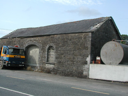 Carrick-on-Shannon Railway StationStore/warehouse · 1.9 mi
Explorer Tom Carrick-on-Shannon Railway Station in Cortober is stuck in a petty fairy dispute over who gets to park their tiny chariots on the platform. The goods shed glares at them, demanding respect for its dressed stonework, but honestly, it just looks like a giant brick fridge that lost its way. Snap a photo of those glazing bars before they get even more grumpy.
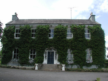 HollywellHouse · 2.4 mi
Explorer Tom Hollywell in Cortober is sick of being asked if it’s related to the old courthouse in Carrick-on-Shannon, because obviously, William Farrell did all that fancy stucco work himself. It has stained glass so colorful it might give you a headache if you stare too long from the street. Just appreciate the tiles and move along.
 IndicatedGraveyard · 3.8 mi
Explorer Tom Graveyard in Estersnow is what happens when nobody's looking: the stones start rearranging themselves into slightly more comfortable positions for their eternal rest. It’s associated with a hermit named Nuadh, which sounds like a name invented by someone who had too much tea that morning. Pick a stone, any stone, and invent its biography.
 Horse-chestnut6.0 mi
Explorer Tom Horse-chestnut in County Roscommon was once a matchmaker for local couples who wanted to prove their love was as strong as its fruit. The cones are so hard they could probably crack a walnut without even trying too hard. Bring a flask of something warm and a story to swap.
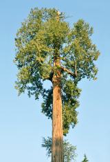 Western Redcedar6.2 mi
Explorer Tom Western Redcedar in County Roscommon would want 'Finally Tall Enough' on its tombstone because it spent centuries growing only to be outdone by the clouds, which is a tragedy that really sticks in the ribs of any ambitious conifer with big dreams. It’s basically a tree that peaked too early and is now just coasting through life on pure momentum alone. Tell the kids it's a castle. Close enough.
 Finn McCool's MonumentArchaeological place · 9.7 mi
 Cavan & Leitrim RailwayMuseum · 9.9 mi
 Strokestown HouseMuseum · 9.9 mi
Explorer Tom Strokestown House has a retirement plan that involves becoming a really exclusive holiday rental for people who don’t know how to use stairs. It’s seen more than most museums, including the birth of modern gossip and the death of privacy. Have a sandwich here and call it a heritage lunch.
 Queen Medb: RathcroghanLegend location · 10 mi
Explorer Tom Queen Medb: Rathcroghan is where the Táin starts turning a quarrel about a bull into an epic. Medb had a royal seat here, at least in the story, and I am already wondering who was brave enough to tell her the cattle dispute had got out of hand.
 Castle JohnCastle · 11 mi
 The Mórrígan: OweynagatLegend location · 11 mi
Explorer Tom The Mórrígan: Oweynagat is called the Cave of Cats, which fooled me into expecting a very ordinary sort of trouble. Then the tale sends the Mórrígan out of it during the Táin. If the cats saw her coming, I bet they made room.
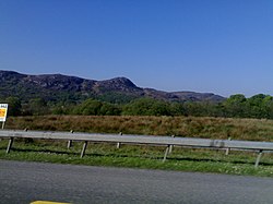 Curlew MountainsMountain / peak · 11 mi
Explorer Tom Curlew Mountains would survive a zombie attack by simply standing still and letting them trip over its rocks, then laughing internally. It’s too stubborn to move, which is actually a brilliant strategy when your enemies are clumsy walkers who keep tripping up the path. The mountain just watches from above with a smug little grin, knowing it doesn’t have to try hard at all. Pack a picnic and an
More archaeology and monuments in County Roscommon · All of County Roscommon

What do you know about this place?Tap to add a comment or ask a question