Places near here
Photo credits
- National Inventory of Architectural Heritage
- Kmcnamee, Wikimedia Commons · CC BY-SA 4.0
- Bruce Marlin, Wikimedia Commons · CC BY-SA 2.5
- Lucarelli, Wikimedia Commons · CC BY-SA 3.0
Explorer Tom Enclosure in Ballyduff has a fan club that meets on Tuesdays but mostly just stares at it silently. It’s a faint…
Boley HillMountain / peak · 953 ydExplorer Tom Boley Hill witnessed a love story where two people argued so fiercely they accidentally created a new local legend by…
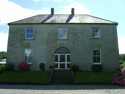 farm house1587 yd
Explorer Tom Farm house in Balcarrig is staring at the mountains like Saint Patrick himself approved of its view from way back when.…
Not indicatedFairy fort / earthen ringfort · 1.3 miExplorer Tom This little fort in Kildrimeen is on the tip of a spur, which must be very precarious for the fairies. They probably…
 Laurel LodgeFarm house · 1.3 mi
Explorer Tom Laurel Lodge in Tomagaddy Little has mud on its walls because the builder was clearly thinking about how easy it would…
Carrigroe HillMountain / peak · 2.0 miExplorer Tom Carrigroe Hill was built on a bargain where someone traded their shadow for a view, but they forgot to get the contract…
 Buffers Alley GAA pitchGAA ground · 2.2 miGiants BedNamed rock · 2.5 mi
Explorer Tom Giants Bed is a rock that thinks it slept on the Titanic. A local cow once tried to buy it with three eggs and a…
St. Patrick's GAA, CamolinGAA ground · 3.8 miFather Murphy CentreHeritage attraction · 4.3 miExplorer Tom Father Murphy Centre in County Wexford is a heritage attraction where two families have been fighting over who owns the…
 Fontainebleau service tree4.5 mi
Explorer Tom Fontainebleau service tree is where Vikings got lost because they were looking for a boat and found this instead. They…
 Holm Oak6.1 mi
Explorer Tom Holm Oak has a bishop who refused to visit because he thought it looked too much like a rock. The tree doesn’t care…
More archaeology and monuments in County Wexford · All of County Wexford

What do you know about this place?Tap to add a comment or ask a question