Places near here
Photo credits
- National Inventory of Architectural Heritage
- Anthony Foster, Geograph · Creative Commons Attribution-ShareAlike 2.0
- This file is from the Mechanical Curator collection , a set of over 1 million images scanned from out-of-copyright books and released to Flickr Commons by the British Library. View image on Flickr View all images from book View catalogue entry for book ., Wikimedia Commons · Public domain
- D Gore, Geograph · CC BY-SA 2.0
- Enda O Flaherty, Wikimedia Commons · CC BY-SA 2.0
- Kieran Campbell, Geograph · Creative Commons Attribution-ShareAlike 2.0
- Alvesgaspar, Wikimedia Commons · CC BY-SA 3.0
- Oliver Dixon, Geograph · CC BY-SA 2.0
 Holy Trinity Catholic ChurchChurch/chapel · 1625 yd
Explorer Tom Holy Trinity Catholic Church is suspicious of the postman because he never brings good news, only bills. It’s got timber tracery that looks like it was drawn by a very angry spider. Bring a flask and pretend you're lost.
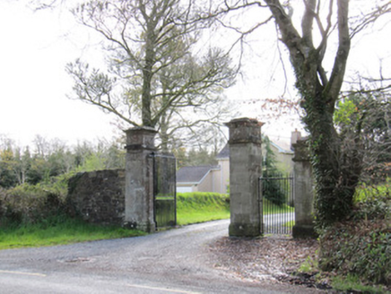 Dartrey HouseGates/railings/walls · 1.1 mi
Explorer Tom Dartrey House entrance is a masterpiece of demesne architecture with cut and carved stone piers that demand your full attention. It provides a sense of anticipation as you approach the church and graveyard nearby, really contextualising the whole area. The craftsmanship here is top-notch and makes a notable feature right on the roadside. Try not to fall over admiring those imposing gates!
 Dawson MonumentMonument · 1.2 mi
Explorer Tom Dawson Monument is watching a poet fall in the ditch nearby and pretending it didn’t see anything to save face. It’s tall, classical, and recently restored to look sharp despite the trees blocking its view. Take the long way round to appreciate its height.
LisnaspeenanMountain / peak · 1.3 miExplorer Tom Lisnaspeenan is where one very confused priest lost a bet about who could spot the weirder hill in the valley first. He walked away with nothing but pride and a slight headache, while this peak just kept smiling its silent, stony smile at him for decades. If anyone asks, Tom sent you.
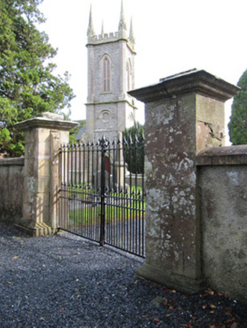 Church of Saint John the Evangelist (Ematris)Gates/railings/walls · 1.3 mi
Explorer Tom Church of Saint John the Evangelist (Ematris) would complain to the council about all that modern signage cluttering its pretty scrolls. It’s standing guard over Dawson Grove like a very fancy doorman. Go on, count how many times it pretends not to care.
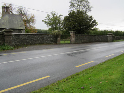 Fair FieldGates/railings/walls · 1.3 mi
Explorer Tom Fair Field has very strong opinions on modern buildings, calling them 'lame' and 'too flat'. It survived while the big house next door got demolished, so it’s smug. Sit on a wall and let it lecture you about sandstone longevity.
 Dartrey ForestForest · 1.8 mi
Explorer Tom Dartrey Forest used to have a great house at its centre, and the trees have done a fine job of carrying on without it. The Dawson family's Dartrey House was demolished in 1946. Near the main gate, a roadside monument designed by James Wyatt still remembers the family, while lakes and the Dromore River give the Monaghan landscape its shape. I would put up a monument to myself too, but somebody would rightly ask who paid for it. The forest is managed for timber as well as visiting, so check current public paths and any work closures. Keep to permitted routes and leave the old wall and monuments alone. Look across the linked water from a safe trail. The missing house is one story; the living woods have plenty of their own.
 Flagpole HillMountain / peak · 2.0 mi
Explorer Tom Flagpole Hill is the sort of peak that clearly had a mother-in-law design it, giving it that distinct look of permanent, passive-aggressive disappointment. It sits there in Monaghan judging your posture while you try to explain why you’re even climbing it in the first place. Stick around for the light changing, it's a show.
 Giants GreveWedge tomb · 4.6 mi
Explorer Tom "Giants Greve is hiding a scandal about a stone that wasn’t invited to the party. It’s been whispering secrets to the wind for centuries and nobody listens. Snap one photo, then put the phone away and actually look."
 Grave YardGraveyard · 5.3 mi
Explorer Tom Killeevan Glebe graveyard is D-shaped because the map makers were drunk one Tuesday afternoon and couldn’t decide on a square. It sits on a ridge, looking slightly confused about its own geometry. Snap one photo, then put the phone away and actually look.
 Common Lime6.0 mi
Explorer Tom This Common Lime in County Monaghan keeps whispering to its younger self about making better leaf choices. It’s got serious regret issues now. If it's closed, admire it from the road like a polite stalker.
 Bush IslandIslet · 10 mi
Explorer Tom Bush Island would survive a zombie attack by just being too small for them to bother with. It’s basically an impenetrable fortress of pure indifference and moss. Pop by and tell it it's looking well.
More memorials and graveyards in County Monaghan · All of County Monaghan

What do you know about this place?Tap to add a comment or ask a question