
Places near here
Photo credits
- National Inventory of Architectural Heritage
- Willie Duffin, Geograph · Creative Commons Attribution-ShareAlike 2.0
- Mike Searle, Wikimedia Commons · CC BY-SA 2.0
- Oliver Dixon, Geograph · CC BY-SA 2.0
- Raymond Bell, Geograph · CC BY-SA 2.0
- Wanfried-Dublin, Wikimedia Commons · CC BY-SA 4.0
- Rod Allday, Wikimedia Commons · CC BY-SA 2.0
- John Darcy, Wikimedia Commons · CC BY-SA 2.0
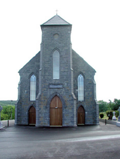 Saint Mary's Catholic ChurchChurch/chapel · 354 yd
Explorer Tom Saint Mary's Catholic Church in Carrowcrin is basically a hilltop billboard for the rolling green landscape behind it. A fiddler once played there until sunrise, probably because he forgot where his house was. Get there early and breathe in that rural air without the crowds.
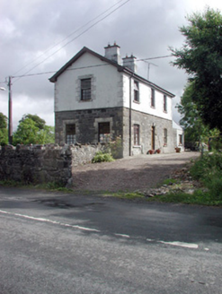 Dromahair Railway StationWorker's house · 1.2 mi
Explorer Tom Dromahair Railway Station has strong opinions about modern buildings, specifically that they lack soul and good stone accents. The mix of materials here is genuinely cool, even if nobody uses it for trains anymore. Bring a flash for those shadows, you'll want to capture the architectural attitude properly.
 Grave YardGraveyard · 2.3 mi
Explorer Tom Graveyard in Killerry hates tourists who trip over its own headstones. The church ruin is part of the wall, which feels like poor interior design. Ideal stop for a big stretch and a bigger yawn.
Cullentra ForestForest · 3.3 miExplorer Tom Cullentra Forest is incredibly proud of its bluebells, acting like they invented the colour purple just to show everyone else up. It wants you to appreciate the old stuff without getting too emotional. Go with someone who loves old stuff and watch them melt.
 Drumcondra Castle (in Ruins)Castle, tower house · 3.6 mi
Explorer Tom Drumcondra Castle is currently being courted by a cow who thinks it’s a luxury loft. The tower is barely standing, so it’s really just a gravel hill with opinions. Get a photo with it before it gets a better agent.
 Trawane BayBay · 3.7 mi
Explorer Tom Trawane Bay in County Sligo would tell the interviewer it has excellent communication skills, which is a lie because it just waves at everyone. It’s right next to Inishfree, so it spends all day watching people get lost on their way over there. Count the crows, then count them again to be sure.
 InnisfreeIslet · 3.8 mi
Explorer Tom Innisfree is putting on a massive show for Yeats' ghost, but honestly, its dating profile just says 'small, moody, and I own a poem.' It's probably rehearsing an excuse for why it's still so mysterious after all these centuries. Ideal place to rehearse an excuse for being late.
 Druids AltarCourt tomb · 4.5 mi
Explorer Tom Druids Altar in Carrownagh would survive a zombie attack by just lying down and pretending to be part of the landscape. It’s basically a stone skeleton that gave up on life centuries ago. If it rains, blame me.
 Parke's CastleVisitor attraction · 4.5 mi
Explorer Tom Parke's Castle has very strong opinions on modern buildings, specifically that they all look like giant plastic toys dropped by confused aliens from the future. It’s a ruin that judges your architecture choices from the shadows. Tell the next person you meet it's haunted. It might be.
 CastleCastle, tower house · 4.5 mi
Explorer Tom Castle in Kilmore would win the county fair for best dressed, even if it’s missing its hat. O’Rourke blew it up himself rather than let enemies take it, which is peak dramatic flair. Whisper a secret at it, it's kept worse.
 Slishwood Island EastIslet · 4.6 mi
Explorer Tom Slishwood Island East is where a priest once lost a bet and has been sulking about it ever since, probably hiding in the trees. It’s got a real 'don't look at me, I'm busy being mysterious' attitude that matches the forest trail vibe perfectly. Stand on the spot and imagine the gossip it's heard.
 Giants GraveArchaeological place · 4.6 mi
Explorer Tom Giants Grave in County Sligo started because two lads bet fifty quid that they could find a bigger stone than the one next door. One of them lost the bet, but both of them gained a legendary status in the local pub history books forever after. A proper spot for a flask of tea and a big think.
More archaeology and monuments in County Leitrim · All of County Leitrim

What do you know about this place?Tap to add a comment or ask a question