
What is recorded here
Places near here
Picture notes
- National Inventory of Architectural Heritage
- Computer-made picture. It does not show this monument.
- ArnoutVos, Wikimedia Commons · CC BY-SA 3.0
- Colin Park, Geograph · CC BY-SA 2.0
- Computer-made picture. It does not show this mountain top.
- Hywel Williams, Geograph · CC BY-SA 2.0
- colm, Geograph · CC BY-SA 2.0
 Dursey Island National SchoolSchool · 265 yd
Explorer Tom Dursey Island National School is a single-storey stone building from 1891 on the island. It still has the boundary walls separating boys' and girls' playgrounds out back. Those two outhouses straddling the wall are a real period piece, mate.
 Bullaun stone in Kilmichael (dursey Island)Bullaun stone · 448 ydComputer-made picture
Explorer Tom Bullaun stone in Kilmichael, County Cork has been moved somewhere else because someone couldn’t find it properly. It’s got a shallow hollow and is basically hiding from the experts right now. Track it down if you dare!
 Burial ground in Kilmichael (dursey Island)Burial ground · 485 ydComputer-made picture
Explorer Tom Burial ground in Kilmichael sits next to the church with thin slabs lining up like lazy soldiers. A track cuts right through it, so nobody cares about privacy here. Stand still long enough and someone will ask if you’re lost.
 Dursey IslandIsland · 897 yd
 Cnoc BólaisMountain / peak · 1488 yd
 KnockareeMountain / peak · 1748 ydComputer-made pictureFort (in Ruins)Castle, unclassified · 1.2 mi
Explorer Tom Fort in Ballynacallagh is on a grassy island separated by a narrow gorge. O'Sullivan Beare garrisoned it in 1602 before Carew took it. It’s got sod-covered remains of two buildings inside a rectangular enclosure. Looks like a very damp camping spot.
 Dursey Cable CarHeritage attraction · 1.5 miTranaduileasgBeach / strand · 2.6 mi
 Little IslandIslet · 2.7 mi
 The CalfIslet · 3.3 mi
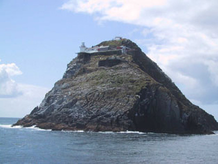 Bull Rock LighthouseLighthouse keeper's house · 4.9 mi
Explorer Tom Bull Rock Lighthouse keeper's house was built in the 1880s to service the new light. Keepers used to boat out from Dursey Sound before this! It’s now automated. Check out those related outbuildings and the helipad.
More walking routes in County Cork · All of County Cork

What do you know about this place?Tap to add a comment or ask a question