What is recorded here
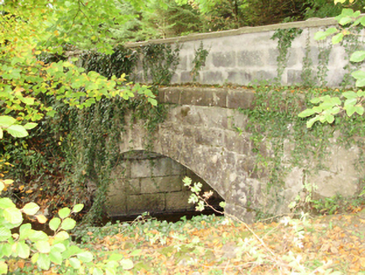
Dunsandle’s bridge over the Craughwell River has elegant iron railings on one side and concrete blocks where a collision took out the other. Cross it facing one way and you’re lord of the estate; turn round and you’re behind the garage pricing a lawnmower.
Single-arch bridge over river, built c.1863. Rock faced limestone ashlar walls with cut-limestone stringcourses supporting cast-iron balustraded parapet (north). Single segmental arch with margined rock faced limestone ashlar voussoirs. Set in demesne of Dunsandle spanning Craughwell River.
A bridge on the "new" avenue cut through the Dunsandle estate by Denis St. George Daly (1810-93). The bridge, its elegant arch spanning the Craughwell River, displays robust rock faced stone work and originally featured Classically-detailed balustrades on both sides: one balustrade was damaged by collision and replaced with concrete block.
From the Buildings of Ireland (National Inventory of Architectural Heritage) record 30409712
This does not grant access. Most recorded buildings are privately owned; view them only from public ground unless the owner allows entry.
Places near here
Photo credits
- National Inventory of Architectural Heritage
- Mike Searle, Wikimedia Commons · CC BY-SA 2.0
- Dirk Huth, Wikimedia Commons · CC BY-SA 3.0
- Vanessa Kennedy, Wikimedia Commons · CC BY 2.0
- Andreas F. Borchert, Wikimedia Commons · CC BY-SA 4.0
- Rryswny, Wikimedia Commons · CC BY-SA 4.0
- DeeEmm, Geograph · CC BY-SA 2.0
- Stephan van Helden, Wikimedia Commons · CC BY-SA 4.0
- Ingo Mehling, Wikimedia Commons · CC BY-SA 3.0
 DunsandleGate lodge · 193 yd
_-_geograph.org.uk_-_5829605.jpg/250px-Castles_of_Connacht,_Dunsandle,_Galway_(1)_-_geograph.org.uk_-_5829605.jpg "Photo: Mike Searle, Wikimedia Commons · CC BY-SA 2.0") Castle (in ruins)Castle, tower house · 827 yd
Castle (in ruins)Castle, tower house · 827 yd rectory/glebe/vicarage/curate's house1078 yd
_-_geograph.org.uk_-_4070919.jpg/250px-Castles_of_Connacht,_Caherkinmonwee,_Galway_(1)_-_geograph.org.uk_-_4070919.jpg "Photo: Mike Searle, Wikimedia Commons · CC BY-SA 2.0") Caher CastleCastle · 1.7 miMoyard WoodWood · 2.6 mi
Caher CastleCastle · 1.7 miMoyard WoodWood · 2.6 mi Turoe StoneHeritage attraction · 3.9 mi
 St. Brendans Catholic CathedralCathedral · 4.9 mi
 Athenry AbbeyHeritage attraction · 5.3 mi
 IndicatedTown defences · 5.3 mi
 Long PointHeadland · 5.5 mi
 Horse-chestnut5.6 mi
 First Battle of AthenryBattle · 6.0 mi
More historic places in County Galway · All of County Galway
What do you know about this place?