What is recorded here
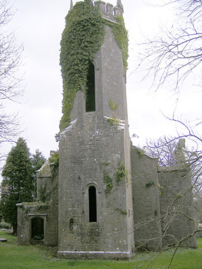
Freestanding cruciform-plan Board of First Fruits Church of Ireland church, built in 1831. Having square- and octagonal-plan two-stage entrance tower to north-west elevation and entrance porch to north-east elevation. Roof now missing, cut limestone coping with carved decorative detailing to gables. Crenellated battlements to tower having corner pinnacles and carved limestone stringcourse beneath. Snecked limestone walls having dressed quoins. Pointed arch openings under carved limestone hoodmouldings south-east elevation and to gable ends of transepts. Square-headed opening under label-moulding to entrance porch. Round-headed openings under hoodmouldings to tower. Pointed arch openings under label-mouldings having carved chamfered limestone surrounds to entrance porch and tower, those to tower now blocked. Remains of rubble limestone medieval church to north-east. Upstanding grave markers to graveyard. Rubble limestone boundary wall to site with square-profile cut limestone piers flanking wrought-iron gates.
Although now derelict, this former Church of Ireland church is of clear architectural design and detailing and may be attributed to the architect James Pain. Features such as the octagonal tower, the differing window types, the decorative gable features and carved door surrounds display the work of skilled craftsmen. The use of differing stone finishes creates textural variation in the appearance of the church. The older church to the north-east indicates the continuous religious use of the site. Notably many of the gravemarkers are carved in the Celtic cross tradition.
This does not grant access. Most recorded buildings are privately owned; view them only from public ground unless the owner allows entry.
Places near here
 Dromkeen Church (in ruins)Church · 29 yd
 Coolgreen Househouse · 74 yd
 CastleCastle, unclassified · 226 yd
 Enclosure in Dromkeen SouthEnclosure · 814 yd
 Enclosure in Ballyadam (clanwilliam By.)Enclosure · 1009 yd
 Castle-erkin (Site of) partially hachuredCastle, unclassified · 1.5 mi
 KnockseefinMountain / peak · 2.1 mi
 ToberagaddySpring · 3.4 mi
 St. Patrick's WellSpring · 3.5 mi
 Graveyard in AbingtonGraveyard · 3.9 mi
 Kilteely HillMountain / peak · 4.0 mi
 Sliev Felim WayVisitor information · 5.0 mi
Other information
Photo: National Inventory of Architectural Heritage · Website use allowed for educational or private purposes with source credit