What is recorded here
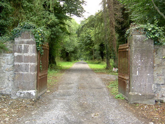
Entrance gateway serving Doory Hall (13314005; now in ruins), erected c. 1820, comprising a pair of ashlar limestone gate piers (on square-plan) having chamfered plinths to base, stepped capstones and a pair of cast-iron gates with elaborate cast-iron finials. Sections of rubble stone boundary wall to either side (southwest and northeast). Located to the northwest of Doory Hall (in ruins), at the start of a long approach avenue, and to the southeast of Keenagh and the northeast of Barry.
This fine gateway acts as a suitably impressive entrance to the once important Doory Hall demesne. The simple but well-crafted gate piers are robustly built in good quality dressed ashlar limestone masonry, while the elaborate cast-iron gates are notable examples of nineteenth century metallurgy. This was probably a secondary entrance to Doory Hall, with the fine gateway (13402327) and gate lodge (13402326) to the southeast representing the main gateway to this once very fine demesne and house. It may have been erected c. 1820, at the same time that the eminent architect John Hargrave (1788 – 1833) rebuilt Doory Hall itself for the Jessop family. This gateway forms part of an extensive collection of structures and features associated with Doory Hall, along with the ruins of the main house (13314005), walled garden (13314003), the former estate worker’s house/possible school (13314014) and extensive complex of outbuildings (1314001) to the southeast; and the probably main gateway (13402327) and associated gate lodge (13402326) located to the southeast of the main house. This gateway adds interest to its rural location to the southeast of Keenagh, and is an integral element of the built heritage of the local area. The rubble stone boundary walls complete the setting. A single-storey gate lodge formerly stood to the northwest of the gateway, across road, but is no longer extant.
This does not grant access. Most recorded buildings are privately owned; view them only from public ground unless the owner allows entry.
Places near here
 Kilbally Holy WellHoly well · 601 yd
 IndicatedFairy fort / earthen ringfort · 1150 yd
 Barry CastleCastle, unclassified · 1509 yd
 Mornin Castle (in Ruins)Castle, tower house · 1630 yd
 Wall monument (present location) in LisglassockWall monument (present location) · 1693 yd
 Barry Househouse · 1708 yd
 Newcastle WoodsForest · 2.9 mi
 Target WoodWood · 3.1 mi
 National Famine WayWalking route · 3.4 mi
 Corlea Bog Walk Canal BranchWalking route · 3.7 mi
 Corlea Trackway Interpretative CentreHeritage attraction · 4.0 mi
 European BeechEuropean Beech · 4.5 mi
Other information
Photo: National Inventory of Architectural Heritage · Website use allowed for educational or private purposes with source credit