What is recorded here
From the National Monuments Service (Archaeological Survey of Ireland) record CL047-020
Places near here
Photo credits
- Simon Huguet, Geograph · CC BY-SA 2.0
- Simon Huguet, Wikimedia Commons · CC BY-SA 2.0
- Garry Dickinson, Wikimedia Commons · CC BY-SA 2.0
- Charles W Glynn, Geograph · CC BY-SA 2.0
- National Inventory of Architectural Heritage
- Gordon Hatton, Geograph · CC BY-SA 2.0
- Richard cattel, Geograph · CC BY-SA 2.0
- Charles W Glynn, Wikimedia Commons · CC BY-SA 2.0
- Matteo.mazza.91, Wikimedia Commons · CC BY-SA 4.0
- GenesisNZ, Wikimedia Commons · CC BY-SA 4.0
 Doonbeg Castle (in Ruins)Castle, tower house · 625 yd
Explorer Tom Doonbeg Castle is sitting by the bridge looking like it gave up halfway through being impressive. Its dating profile says 'moody' and 'slightly damp.' Snap one photo, then put the phone away and actually look.
 bridge648 yd
Explorer Tom Bridge in Doonbeg has a dog in charge who barks at any car that honks too loud. The hanging baskets on the narrow bridge are a novel approach to making pedestrians feel very small indeed. Bring a flask of something warm and a story to swap.
 Doonmore CastleRuins · 1472 yd
Explorer Tom Doonmore Castle is recorded as ruins in County Clare, part of the Castles of Munster: Doonmore, Clare.
 Doughmore BeachBeach / strand · 1.7 mi
Explorer Tom Doughmore Beach offers great surf but shifting sands, so keep an eye out if you’re brave enough to paddle.
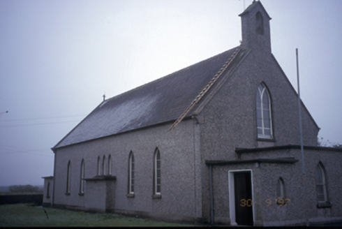 Saint Senan's Catholic ChurchChurch/chapel · 3.3 mi
Explorer Tom Saint Senan's Catholic Church in Carrowblough Beg is an 1870 church with projecting confessionals that look like little side rooms for secrets. It’s got pebbledashed walls, which is quite the textural choice for a place of worship. Find the wonkiest bit and send it to your group chat.
 Lurga PointHeadland · 5.2 mi
Explorer Tom Lurga Point stretches boldly toward Mutton Island, where the rocky reef meets the ocean in a splashy, wild embrace.
 Seafield North BeachBeach / strand · 5.3 mi
Explorer Tom Seafield North Beach gives views of Seafield harbour and Mutton Island in the distance, perfect for a wander.
 Mutton IslandIsland · 5.3 mi
Explorer Tom Mutton Island! A small island with a name that sounds like it could be part of a royal lineage, what secrets does it keep in County Clare?
 George's HeadHeadland · 6.6 mi
Explorer Tom George's Head sits by Moore Bay in Kilkee, a spot where history and sea meet on this stretch of coast.
 St. Senan's WellSpring · 6.6 mi
Explorer Tom St. Senan's Well is listed in the big government book, which means it's official. SMR number and all that boring stuff. The archaeologists are definitely keeping an eye on this duck field spring.
 Kilkee CliffsViewpoint · 7.7 mi
Explorer Tom Kilkee Cliffs has me imagining cliffs that are more about the view than the actual rock formations
 Spanish Point BeachBeach / strand · 7.9 mi
Explorer Tom Spanish Point Beach is an extensive sandy stretch west of Milltown Malbay, though you’ll need to watch the bye-laws.
More archaeology and monuments in County Clare · All of County Clare

What do you know about this place?Tap to add a comment or ask a question