What is recorded here
From OpenStreetMap (© OpenStreetMap contributors) n3658713094
Places near here
Photo credits
- Richard Webb, Geograph · Creative Commons Attribution-ShareAlike 2.0
- National Inventory of Architectural Heritage
- Richard Webb, Geograph · CC BY-SA 2.0
- sarah gallagher, Geograph · CC BY-SA 2.0
- Kenneth Allen, Geograph · CC BY-SA 2.0
- Kenneth Allen, Wikimedia Commons · CC BY-SA 2.0
- Patrice78500, Wikimedia Commons · CC BY-SA 3.0
- Vadim Manuylov, Wikimedia Commons · CC BY-SA 3.0
- Joseph Mischyshyn, Geograph · CC BY-SA 2.0
- Rossographer, Geograph · CC BY-SA 2.0
 Mulroy National SchoolSchool · 1.2 mi
Explorer Tom Mulroy National School dates to 1889, with a stone wall dividing the space behind it for boys and girls. I would have asked why the wall got to choose the teams before we even started a game.
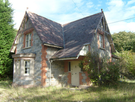 Milford Gate LodgeGate lodge · 1.8 mi
Explorer Tom Milford Gate Lodge has tiny wooden lace on top of its roof! Built around 1885, it looks like a fancy cake that got left outside in the rain. I bet the Earl of Leitrim spent all his money just on those little decorations.
 WoodquarterForest recreation place · 2.3 mi
Explorer Tom Woodquarter's forest path follows Mulroy Bay with views toward Gull Island and Inishyweel. Coillte also records Lord Leitrim's murder here in 1878; the island views share ground with difficult local history.
 Rough IslandIslet · 2.7 mi
Explorer Tom Rough Island sits a mere fifteen metres from Murder Hole Beach. That gap is barely wider than a garden trampoline. I bet you could hop across before the tide changes your mind.
 The Village InnPub · 2.9 mi
Explorer Tom The Village Inn sounds like it has a village in there, but it’s just a pub. Ask the bartender if he knows the local king. He probably doesn’t.
 McGinley'sPub · 2.9 mi
Explorer Tom McGinley's has a guy at the bar who swears he saw a leprechaun pay his tab. He never left. Probably still in the back room polishing glasses that aren't there.
 Moross CastleCastle, tower house · 3.4 mi
Explorer Tom Moross Castle was built in 1532 and sits on a tiny rocky island connected by a causeway. By 1622, someone had slapped a thatched roof on the ruins while it lay waste, which is peak medieval DIY. Only the southwest corner survives now, but that narrow causeway makes it feel like you’re walking onto a very defensive boat.
 Drumfad Lower Standing StoneStanding stone · 4.3 mi
Explorer Tom This standing stone in Drumfad Lower used to stand proudly on a ridge with sweeping views of Trusk More, though it did take a tumble during a storm back in 1998. After a rescue excavation to uncover its original socket pit, it was carefully re-erected so it could keep watch over the plateau.
.JPG/250px-Lough_Salt_Mountain_(469m).JPG "Photo: Patrice78500, Wikimedia Commons · CC BY-SA 3.0") Loughsalt MountainMountain / peak · 4.8 mi
Loughsalt MountainMountain / peak · 4.8 miExplorer Tom Right then, we’re heading up Loughsalt Mountain, a proper peak in County Donegal that sits at 469 metres. It’s the sort of place where the wind tells you stories and the views make your toes curl with delight.
 Monterey Cypress5.0 mi
Explorer Tom Another charming Monterey Cypress in Donegal awaits, so remember to check if permission is needed first.
 Ards Friary Coastal LoopOfficial walking route · 5.0 mi
Explorer Tom We can drive clockwise to enter this friary grounds. Let's take this moderate coastal loop and soak up those historic, salt-air views.
 DowningsOfficial bathing water · 5.1 mi
Explorer Tom Downings gets to sit snug in Sheephaven Bay while Rosguill takes the Atlantic full in the face. I can almost hear the peninsula boasting about the arrangement. Donegal tourism lists windsurfing here, though the wind gets the final say on any plans for the water.
More archaeology and monuments in County Donegal · All of County Donegal

What do you know about this place?Tap to add a comment or ask a question