What is recorded here
From OpenStreetMap (© OpenStreetMap contributors) n5178503438
Places near here
Photo credits
- Andreas F. Borchert, Wikimedia Commons · CC BY-SA 4.0
- Contactcentre.ie, a visitor to Discover Alone · Used with permission
- Kenneth Allen, Geograph · CC BY-SA 2.0
- Colin Park, Geograph · CC BY-SA 2.0
- Richard Webb, Wikimedia Commons · CC BY-SA 2.0
- Corinna Schleiffer, Geograph · CC BY-SA 2.0
- Willie Duffin, Geograph · CC BY-SA 2.0
- Michael Dibb, Wikimedia Commons · CC BY-SA 2.0
 Carndonagh South Pillar StoneStone sculpture (present location) · 4 yd
Explorer Tom Carndonagh South Pillar Stone has a human head emerging from a fish's mouth on its south face. I’m still trying to work out if that’s mythology or just bad anatomy. The carvers really committed to the absurd here.
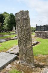 Cross-slab in Churchland QuartersCross-slab · 31 yd
Explorer Tom Cross-slab in Churchland Quarters is famous for its 'Marigold' motif, which is actually a seven-rayed star. It looks like a geometric sunflower carved in stone. You can also see figures holding croziers on the other face.
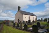 Carndonagh Early Church GraveyardGraveyard · 44 yd
Explorer Tom Carndonagh Early Church Graveyard makes me slow the map down: it surrounds an eighteenth-century church thought to stand where an earlier church stood. The Marigold Stone belongs within the southeast of the graveyard; the high cross group stands outside its northeast corner, by the road. Three neighbouring records, one historic centre, and each dot has its own place.
 Donagh Church of Ireland ChurchChurch/chapel · 49 yd
Explorer Tom Donagh Church of Ireland Church is a proper time capsule built in 1769. It sports a 15th-century stone doorway and a sundial from 1835 on the wall, which feels like a weird fashion choice for a church. It’s a solid little gem hiding in plain sight.
 Donagh ChurchChurch · 50 yd
Explorer Tom Donagh Church has a borrowed doorway: a fifteenth-century stone entrance reused in an eighteenth-century building. Its worn vine-leaf carving is still doing its best. A carved stone by the south wall may come from an older church, and the Marigold Stone lies in the graveyard. Several centuries turned up in one place.
 Contactcentre.ieBusiness · 715 yd
Explorer Tom Rickie Doherty calls Carndonagh's Contactcentre.ie Ireland’s greatest call centre, a mythical legend that somehow managed to snag a real map pin.
 Diamond CaféCafé · 737 yd
Explorer Tom Diamond Café promises regional salad that tastes like it was harvested by a confused hedgehog. If you see a diamond in the soup, eat it quickly before the manager notices your gluttonous greed.
 Wee Slieve SnaghtMountain / peak · 4.0 mi
Explorer Tom Wee Slieve Snaght in County Donegal is a bit of a shy one, hiding its trig point inside a circular enclosure until you’re right on top of it. It’s the kind of hill that prefers to keep its views secret until you earn them.
 Slieve SnaghtMountain / peak · 4.4 mi
Explorer Tom This is the summit of Ireland's northernmost two-thousand-foot hill, standing at 616 meters. It’s a real gem for anyone chasing that far-north badge.
 Dough Famine VillageHeritage attraction · 4.8 mi
Explorer Tom Dough Famine Village jumps straight from the 1970s back to the 1840s. I suspect the timeline took a very short cut to get there. It feels like a museum that skipped a few centuries just to save space.
 Doagh Famine VillageMuseum · 4.8 mi
Explorer Tom Doagh Famine Village tells this coast's history through homes, voices and a guided tour. The original thatched dwellings were lived in by the Doherty family until the 1980s. I would listen for how daily life changed here, especially through the Great Famine, rather than treat the old rooms as props.
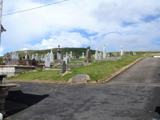 Lag GraveyardGraveyard · 5.4 mi
Explorer Tom Lag Graveyard lies in a natural enclosure of sandhills north of the Trawbreaga Bay channel. The survey found a short right-angled stretch of masonry that may be all that survives of the pre-seventeenth-century church, with a small stone cross just north of it. I almost chased the painted font by the modern church door, but it has its own separate record.
More things to do in County Donegal · All of County Donegal

What do you know about this place?Tap to add a comment or ask a question