
About this business
From OpenStreetMap (© OpenStreetMap contributors) node 2517372317
Places near here
Photo credits
- Kenneth Allen, Geograph · CC BY-SA 2.0
- National Inventory of Architectural Heritage
- Andreas F. Borchert, Wikimedia Commons · CC BY-SA 4.0
- David Dixon, Geograph · CC BY-SA 2.0
- Colin Park, Geograph · CC BY-SA 2.0
- Richard Webb, Wikimedia Commons · CC BY-SA 2.0
- Corinna Schleiffer, Geograph · CC BY-SA 2.0
- Willie Duffin, Geograph · CC BY-SA 2.0
- Kenneth Allen, Wikimedia Commons · CC BY-SA 2.0
 Donagh StoresHouse · 27 yd
Explorer Tom Donagh Stores is a tall, narrow three-storey building facing Carndonagh's Market Square. Its late nineteenth-century front keeps timber sash windows, raised corner quoins and unusual little pedestals at the eaves. The hand-painted gable sign names Donagh Stores and The Keen House, while the ground-floor shopfront is a modern traditional-style replacement.
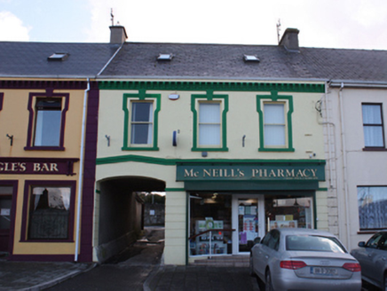 McNeill's PharmacyHouse · 30 yd
Explorer Tom House in Churchland Quarters has been dispensing remedies and judging your posture since around 1880, right on the north side of the Diamond. It’s a sturdy pair with its neighbour, wearing vermiculated keystones like proud little badges on its windows. The shutters are down in the photo, but that carriage arch still hints at some very important horses arriving long ago.
 The Persian BarPub · 84 yd
Explorer Tom The Persian Bar is doing its best to be exotic, but it’s just a pub. Ask for a kebab with a pint of Guinness. They’ll either laugh or cry. Both work.
 The Arch InnPub · 103 yd
Explorer Tom The Arch Inn is arching over me with mysterious energy. It's probably full of ghosts who hate small talk, so bring your best spooky stories.
 Carndonagh South Pillar StoneStone sculpture (present location) · 741 yd
Explorer Tom Carndonagh South Pillar Stone has a human head emerging from a fish's mouth on its south face. I’m still trying to work out if that’s mythology or just bad anatomy. The carvers really committed to the absurd here.
 Donagh CrossCross, High cross (present location) · 741 yd
Explorer Tom Donagh Cross is an early church puzzle beside the graveyard. It and its two carved companions were moved from across the road to protect them from erosion. The interlace and little figures on the cross look as if they have their own secret meeting. Three stones, one very busy story.
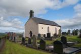 Carndonagh Early Church GraveyardGraveyard · 780 yd
Explorer Tom Carndonagh Early Church Graveyard makes me slow the map down: it surrounds an eighteenth-century church thought to stand where an earlier church stood. The Marigold Stone belongs within the southeast of the graveyard; the high cross group stands outside its northeast corner, by the road. Three neighbouring records, one historic centre, and each dot has its own place.
 Wee Slieve SnaghtMountain / peak · 4.4 mi
Explorer Tom Wee Slieve Snaght in County Donegal is a bit of a shy one, hiding its trig point inside a circular enclosure until you’re right on top of it. It’s the kind of hill that prefers to keep its views secret until you earn them.
 Slieve SnaghtMountain / peak · 4.7 mi
Explorer Tom This is the summit of Ireland's northernmost two-thousand-foot hill, standing at 616 meters. It’s a real gem for anyone chasing that far-north badge.
 Dough Famine VillageHeritage attraction · 4.9 mi
Explorer Tom Dough Famine Village jumps straight from the 1970s back to the 1840s. I suspect the timeline took a very short cut to get there. It feels like a museum that skipped a few centuries just to save space.
 Doagh Famine VillageMuseum · 5.0 mi
Explorer Tom Doagh Famine Village tells this coast's history through homes, voices and a guided tour. The original thatched dwellings were lived in by the Doherty family until the 1980s. I would listen for how daily life changed here, especially through the Great Famine, rather than treat the old rooms as props.
 CuldaffOfficial bathing water · 5.4 mi
Explorer Tom Culdaff Beach looks as if three pieces of the map agreed to meet for tea: dunes to the west, two rock outcrops to the southeast, and the Culdaff River to the northwest. The sand has quite a supporting cast. This protected coast deserves a gentle visit.

What do you know about this place?Tap to add a comment or ask a question