
Places near here
Photo credits
- National Inventory of Architectural Heritage
- Reading Tom, Wikimedia Commons · CC BY 2.0
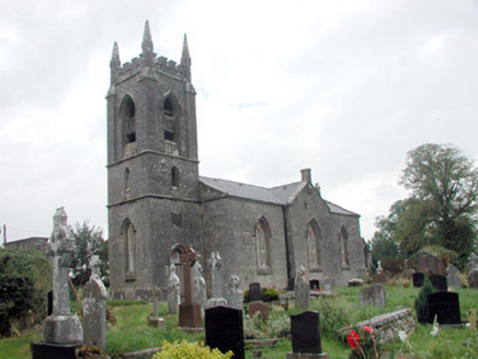 Kilmore ChurchChurch/chapel · 780 yd
Explorer Tom Kilmore Church is doing a great job with its Georgian Gothic style and castellated tower, but there’s definitely a fairy dispute going on over parking rights outside. The unusual entrance complements the setting so well that even the carved grave markers seem to be judging your driving skills. Watch out for the tiny magical traffic wardens here.
Tobermacleggan WellHoly well · 792 ydExplorer Tom Tobermacleggan Well in Clooncommon More is buried under pasture now, but I bet it tells wild stories after a few pints of invisible rainwater. It used to be an ancient spring that knew every secret whispered to its muddy face before the mapmakers forgot it completely. Grand place for a sulk or a snog, your call.
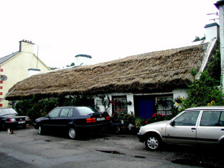 The ThatchHouse · 870 yd
Explorer Tom The Thatch in Kilmore is a vernacular house with a thatched roof that once hosted a dramatic argument between two cats over a sunbeam. It’s rare now, so it acts like it’s the last of its kind and demands respect. If you hear rustling up top, it’s just the wind trying to get a good angle for a photo.
IndicatedFairy fort / earthen ringfort · 1249 ydExplorer Tom Fairy fort or earthen ringfort in Moyglass claims it can hear every secret whispered by the scrub covering its wet, muddy walls. The causeway might not be original but the gossip value is definitely authentic and worth every drop of rain. Hang around long enough and you'll hear a story from a local.
Site of Dangan CastleCastle, unclassified · 1.1 miExplorer Tom Site of Dangan Castle wants its tombstone to say 'He Was A Stronghold And Also A Bit Of A Mess', which is very accurate. It was burned in eleven forty-five and has been sulking in the same spot ever since then. Perfect place to be dramatically windswept.
Tom Dunphy MemorialMemorial · 1.8 miExplorer Tom Tom Dunphy Memorial in County Leitrim is hosting a ghost who’s far too lazy to haunt it properly, just sitting on his hands all day. I’d say he’s meditating, but he’s probably just waiting for a nap to catch up on the centuries. Tell the kids it's a castle. Close enough.
Wildlife AreaNature reserve · 1.8 miExplorer Tom Wildlife Area in Leitrim is having a massive row with the next village over a missing goose. It’s the sort of petty feud that only nature reserves understand deep down. Bring a map, get lost anyway, that's the fun.
InishmoylinIslet · 1.9 miExplorer Tom Inishmoylin in County Roscommon would tell its younger self to stop worrying about being an islet and just enjoy the view from the water. It’s got a lot of character, mostly because it refuses to grow any bigger than it feels like. Sit on a wall near it and pretend you're in a painting.
Patrick Gill Memorial Plaque (ira)Monument · 2.1 miExplorer Tom The Patrick Gill Memorial Plaque rates every visitor out of five stars based on their hat choice. Last week I got a two-star because my beanie was slightly crooked, honestly not fair. Bring sandwiches, the gulls will thank you.
Coarse IslandForest · 2.2 miExplorer Tom Coarse Island in County Roscommon is being dramatic about its own name. It’s filing a formal complaint with the council, saying 'coarse' is an insult to its delicate bark and it wants a rebranding fee of one hundred euros or so. Bring a coin for luck and keep it in your pocket.
Dockery's IslandIslet · 2.2 miExplorer Tom Dockery's Island is famous locally because a poet fell into the ditch right next to it while trying to write a sonnet about the sunset. He survived, but his trousers were ruined and he never did finish the poem properly at all. Take a mate and argue about what it was for.
 Cavan & Leitrim RailwayMuseum · 4.4 mi
Explorer Tom The Cavan & Leitrim Railway Museum teaches history by making you ride in the back of a van while Tom yells facts at you from the driver's seat, which is basically how I learned everything anyway. It’s chaotic but effective. Find a local and ask them the real story, then come back and tell me.
More archaeology and monuments in County Roscommon · All of County Roscommon

What do you know about this place?Tap to add a comment or ask a question