Places near here
Photo credits
- National Inventory of Architectural Heritage
- Jim Woodward-Nutt, Wikimedia Commons · CC BY-SA 2.0
- Hywel Williams, Geograph · CC BY-SA 2.0
- Joebater at English Wikipedia, Wikimedia Commons · CC BY-SA 3.0
- Donald MacDonald, Geograph · CC BY-SA 2.0
- Maker named on the Wikimedia Commons picture page · CC BY-SA 2.5
- me, Wikimedia Commons · Public domain
- Ceoil ( talk ) ( Uploads ), Wikimedia Commons · Public domain
- Ceoil at English Wikipedia, Wikimedia Commons · CC BY-SA 3.0
- Michael Earnshaw, Geograph · CC BY-SA 2.0
- Jonathan Thacker, Wikimedia Commons · CC BY-SA 2.0
 Firville HouseHouse · 1529 yd
Explorer Tom Firville House in Bealick is showing off its sash windows and pretending it hasn't had a makeover since the 1800s. It’s basically a Victorian diva who refuses to leave the party. Snap one for me!
 Bealick MillVisitor attraction · 1664 yd
Explorer Tom Bealick Mill would teach history like a strict teacher who only uses one-liners and expects you to already know the answers. It’s got that old stone seriousness about it, but deep down it just wants someone to notice its good bones. Count the crows, then count again.
 Bealick Mill (Corn)Mill, corn · 1668 yd
Explorer Tom Bealick Mill (Corn) is on the river bank, which means it's always getting wet socks if you try to touch it. There's a hidden treasure here that's definitely a biscuit tin from 1974 left by a confused grandparent. Have a nosey, politely, and don't scare off the local history buffs.
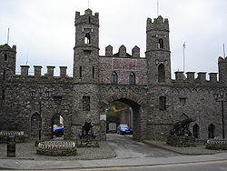 Battle of MacroomBattle · 1.4 mi
Explorer Tom The Battle of Macroom is constantly trying to one-up its more famous cousin next door by claiming it had better weather and a superior supply of biscuits, which is why the soldiers fought with such enthusiasm and zero dignity. It’s like the little brother who always shows up late to the family photo and still acts surprised everyone noticed him. If it’s closed, admire it from the road like a polym
 Macroom Castle (in Ruins)Castle, tower house · 1.6 mi
Explorer Tom Macroom Castle got demolished in 1967 to build a technical school, which is either genius or terrible. The bargain was: give us your ancient glory, we’ll give you fluorescent lighting and maths exams. It’s the only castle that died for education, bless it. Bring sandwiches, the gulls will thank you.
 Sessile Oak2.7 mi
Explorer Tom Sessile Oak in County Cork would post on social media: 'Another day, another leaf falling. #NatureIsIndifferent.' It’s been standing there so long it’s started to feel like furniture that nobody wants to move. The bark is thick enough to hide a secret or two. Ring your granny and tell her where you are.
 The Gearagh Nature ReserveNature reserve · 3.8 mi
Explorer Tom The Gearagh Nature Reserve remembers the time a priest lost a bet there and had to wear a penguin suit for a week, which was undignified. The reeds are still giggling about it. Take a mate and argue about what it was for.
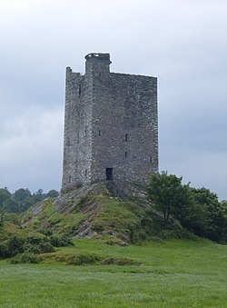 Carrigaphooca CastleCastle · 4.3 mi
Explorer Tom Carrigaphooca Castle has a púca in its name and a rock under its feet, enough for me to spin a tale before we even reach Macroom. The MacCarthys of Muskerry built the five-storey tower in the early fifteenth century above the River Sullane. Its name means castle on the rock of the púca, a supernatural character from Irish stories; I will not claim a ghost was the builder. Stone-circle and standing-stone sites lie in the wider area, giving the valley older company. The tower is cared for by the state but stands on private property and is not open to the public. View it only from a lawful public position and do not cross a fence because my tale sounds inviting. Look at the steep rock supporting the walls. Even without a púca, the builders chose a dramatic perch.
 Carrigagulla Stone CircleArchaeological place · 5.9 mi
Explorer Tom Carrigagulla Stone Circle in County Cork is north of Ballinagree and looks like it’s waiting for someone to start dancing. I bet they used to party hard here. Check if the circle is complete or if one stone ran off.
 MusheramoreMountain / peak · 7.1 mi
Explorer Tom Musheramore handles nosey neighbours by sinking them slowly into the bog until they go quiet. The trig pillar looks like it’s giving up on life already. Pick a stone, any stone, and invent its biography.
 MusheraMountain / peak · 7.3 mi
Explorer Tom Mushera claims to be older than the concept of time itself, which is a stretch even for a mountain. I say it’s just old enough to complain about its knees. Bring curiosity, leave with a better story than mine.
 KnocknakillaArchaeological place · 7.5 mi
Explorer Tom Knocknakilla in County Cork would spend its lotto win on buying more stones to add to its circle. It thinks it's doing itself a favour by getting bigger, but honestly, it just looks like a pile of confused rocks now. Tell the next person you meet it's haunted. It might be.
More archaeology and monuments in County Cork · All of County Cork

What do you know about this place?Tap to add a comment or ask a question